Rim Fire
The Rim Fire was a massive wildfire that started in a remote canyon in the Stanislaus National Forest in California's Tuolumne County.
Parts of what became the footprint of the Rim Fire had accumulated large amounts of combustible vegetation and other fuels following decades of wildfire suppression and logging of larger, older, and more fire-resistant trees.
[3][4] Following a series of large wildfires in 1987, thousands of acres in the Stanislaus National Forest had been replanted with pine tree plantations, which—un-thinned and uniform in size—became fuel for the Rim Fire.
[3][5] In the winter and spring of 2012–2013, California received below-normal amounts of precipitation:[3] less than half of the average for the eight months directly prior to the fire.
A nearby weather station reported at 3:00 p.m. that the temperature was 87 °F (31 °C), the relative humidity was 17 percent, and winds were reaching 15–21 miles per hour (24–34 km/h) out of the west.
[8][9] Firefighters quickly assessed the Rim Fire as having burned 40 acres (16 ha) while still growing at a "dangerous rate of spread".
[10] On August 28, after emergency approvals, an MQ-1 Predator unmanned aerial vehicle flew over the area, providing infrared video of lurking fires.
At one point, state officials asked residents to avoid social media, to stop exaggerated claims and rumors from spreading, and debunked a number of circulating stories.
[26] The fire also threatened the Hetch Hetchy reservoir, the main source of water for San Francisco, providing up to 85% of the city's supply[27] to 2.6 million customers.
[29][30] The fire advanced to within a mile of Hetch Hetchy by Monday, August 26, which was a concern to O'Shaughnessy Dam officials due to ash falling in the water.
[33] During the Rim Fire, forest closures were put into effect and evacuation orders were issued by the Tuolumne and Mariposa County Sheriff's Offices.
At the height of the danger, an estimated 15,000 residents were under evacuation order or advisory, with plans drafted by a Search & Rescue Incident Management Team [35] to evacuate the communities of Groveland, Pine Mountain Lake, Big Oak Flat, Tuolumne City, Tuolumne Rancheria, Ponderosa Hills, Sherwood Forest, Sugar Pine, and Miwuk Village.
[37][38][39] The safety rationale was questioned, as Yosemite National Park, which largely prohibits mushroom collecting, had opened up the burn areas within its boundaries to the public earlier in the month.
[37][38][41] The closure of the burn area was also criticized by the Tuolumne County Board of Supervisors for, among other reasons, causing the cancellation of grazing allotments by local ranchers.
[43]The United States Forest Service made it their highest priority fire at the time because of the threat to local communities and its proximity to Yosemite National Park.
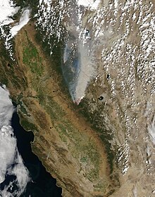
From Yosemite to the San Joaquin Valley, air quality reached unhealthy levels several times, according to the National Weather Service.
[53] During Labor Day weekend, parts of Yosemite National Park are filled with thick smoke, pushing air quality indices to unhealthy levels and obscuring views.
[63] On August 28, 2014, Stanislaus Forest supervisor Susan Skalski signed a Record of Decision approving the Rim Fire Recovery Project.
The Forest Service said that the final plan reflected a collaboration between the timber industry and various environmental groups, who had joined in an attempt to find consensus on the recovery process.
[65] In August 2016, Stanislaus Forest supervisor Jeanne M. Higgins signed a Record of Decision approving the Rim Fire Reforestation Project.