Hoddle Grid
In response, the Imperial authority in London authorised William Lonsdale to lead a party to establish an official settlement the following year.
This grid layout was later adopted by surveyor Robert Hoddle when he arrived in early 1837 with New South Wales Governor Bourke in order to continue survey of the area and regularise the fledgling unauthorised settlement.
[2] The placement of the grid was determined firstly by the fact that the fledgling settlement was already established at that point on the Yarra River, next to a natural shipping basin, just below a rocky outcrop known as 'the falls', above which the water was usually fresh.
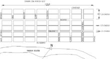
However, at Governor Bourke's insistence, 'little streets' were inserted east west through the middle of the blocks to allow for rear access to the long, narrow allotments.
Instead, simple grid plans, with lots or blocks set aside for public buildings and sometimes a park, were standard practice across Australia in government settlements, to facilitate the creation of regular allotments for sale.
The swampy area to the south soon hosted rail lines, with many suburban trains converging on Flinders Street railway station near Princes Bridge, the gateway to the city from the south, and Spencer Street station on the western edge was the terminus for country trains, as well as more suburban lines.
The CBD still retains a central role for retail, with flagship department stores, specialist shops, and luxury brands, and the upper floors of older buildings and down the city's famous laneways host a busy nightlife of numerous bars and restaurants, and a street art culture.
While it has long been well known that Robert Hoddle surveyed the first officially published plan of the central grid of streets most commonly referred to as 'the City', it was not traditionally named after him.
In the 19th and early 20th Century the focus was more on Collins Street, the grandest thoroughfare, with the most expensive and exclusive buildings along its length, while the western and northern edges comprised unremarkable low rise residential and light industrial development.
[9] The phrase 'CBD' or Central Business District appears in the 1960s, probably within the publication of the 'Borrie Report' in 1964, and the subsequent Melbourne Metropolitan Planning Scheme, enacted in 1968.
The grid's longest axis is oriented 70 degrees clockwise from true north, to align better with the course of the Yarra River[citation needed].