Horsepen Creek (Little Nottoway River tributary)
The watershed is 66% forested and 32% agricultural with the rest of land as other uses.
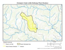
[4] Horsepen Creek rises about 0.1 miles east of Winnie, Virginia on the Nottoway River divide in Nottoway County.
The creek then flows southeast and east through Lake Amtoco to meet the Little Nottoway River about 2 miles southwest of Blackstone.
Horsepen Creek drains 7.17 square miles (18.6 km2) of area, receives about 45.6 in/year of precipitation, has a topographic wetness index of 404.31 and is about 76% forested.
This article related to a river in Virginia is a stub.