Hula Valley
In the 1st century CE, the Jewish-Roman historian Flavius Josephus termed it Semechonitis (Greek: Σημεχωνίτις, romanized: Sēmekhonítis), John Lightfoot writing it as Samochonitis,[4] while in the Talmud it is called the Sea/Lake of Siwkhi (יַמָּהּ שֶׁל סִיבְכִי, Siḇḵi[clarification needed]).
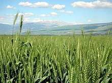
The Hula Valley was a main junction on the important trade route connecting the large commercial centre of Damascus with the Eastern Mediterranean coast and Egypt.
At some point, the area came under the control of the Israelites, until it was captured by the Neo-Assyrian Empire's armies under Tiglath-Pileser III (reigned 745–727 BC) and its inhabitants were driven away.
In the 19th century, the valley, mainly marshy ground and a shallow lake, was inhabited by Ghawaraneh Bedouin[8] who wove matting from the papyrus with which they built their homes.
John MacGregor, a Victorian adventurer, was captured with his boat, the "Rob Roy", by dark-skinned Bedouin living in the Hula marshes.
[citation needed] In 1882, a traveler wrote that the region was "among the finest hunting grounds in Syria," home to "panthers, leopards, bears, wild boars, wolves, foxes, jackals, hyenas, gazelles and otters."
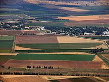
In 1933, during the British Mandate, the Zionist Palestine Land Development Company was awarded this concession by the Mandatory government and drew up plans to drain and irrigate the valley which brought scientific expeditions to the area.
[dubious – discuss] On both sides of the valley are steep slopes: the Golan Heights to the east and the Upper Galilee's Naftali Mountains to the west rise to 400 to 900 meters above sea level.
Basalt hills of about 200 meters above sea level along the southern side of the valley intercept the Jordan River, and are commonly referred to as the basalt "plug", the Korazim block, or Korazim Plateau (actually a temporary geologic base level), as they restrict water drainage downstream into the Sea of Galilee.
The Hula Valley has a Mediterranean climate of hot dry summers and cool rainy winters, although its enclosure within two mountain ranges leads to more extreme seasonal and daily temperature fluctuations than in coastal areas.
It abounds in snipe, wild ducks, francolins and many other kinds of birds, and is consequently much resorted to by the hunter, but as carefully avoided by the inhabitants on account of the noxious fever.
[16] Though perceived at the time as a great national achievement for Israel, with the advent of the modern environmental movement, it became evident that the transformation of the swamp into agricultural land involved significant trade-offs and had effects on the ecosystem that had not been perceived in the first half of the twentieth century, when the major concerns had been the reduction of malaria-bearing mosquitoes and improving economic productivity.
The soil, stripped of natural foliage, was blown away by strong winds in the valley, and the peat of the drained swamp ignited spontaneously, causing underground fires that were difficult to extinguish.
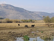
In 2011, Israeli ornithologists confirmed that Lake Hula is the stopover point for tens of thousands of cranes migrating from Finland to Ethiopia every winter.
[24] In November 2011 the Hula painted frog, classified as extinct since 1996 by the IUCN as a result of the marsh drainage, reappeared to park patrollers in HaHula.