Hutchinson River
The New York State Department of Environmental Conservation rates the entire stream as impaired to an extent that it cannot be used as drinking water or recreationally; local authorities discourage eating any fish caught from the Hutchinson.
The main stem of the Hutchinson rises from a confluence of two short streams off Brookline Road in an extensively developed residential area of single-family homes on large lots in Scarsdale, at an elevation roughly 235 ft (72 m) above sea level.
[15] Another 500 ft (150 m) below that bridge, as the river again divides houses in the narrowing space between Clarence Road on the west and Charlotte Lane to the east, it becomes the boundary between New Rochelle and Eastchester.
[20] It flows out through a narrow spillway on the lake's southeastern shore, crossing under a footbridge and then immediately bending southwest[21] to begin several miles of closely paralleling the Hutchinson River Parkway, a four-lane limited-access grade-separated highway.
From there it continues flowing, first through a small unnamed lake, slightly to the southwest through the wooded parkland to the 18.3-acre (7.4 ha) Reservoir 2,[27] 95 ft (29 m) above sea level.
After almost a half-mile (900 m), the Hutchinson flows out the spillway of another dam just above a state highway garage complex adjoining the interchange with the Cross County Parkway.
[47] South of the Glover complex the Hutchinson widens, bears more to the southwest, further away from the parkway, and enters an industrial area, with tank farms and warehouses aside.
[49] The river veers slightly into a straight south-southwest course, now wide enough that barges can moor along its banks, and 500 feet from the pipeline it is briefly entirely within Mount Vernon as Pelham Manor gives way to the New York City borough of The Bronx on the east side.
[51] South of the Thruway, the Hutchinson bends again to a south-southwest course, now a hundred feet wide, flowing straight between an industrial area on its west and wetlands on the east, part of the Thomas Pell Wildlife Sanctuary in nearby Pelham Bay Park.
[52] After flowing past Co-Op City for 0.6 mi (0.97 km), the Hutchinson, now below 10 ft (3.0 m) in elevation, with a dredged channel in its middle,[53] bends southeast as the parkway crosses for the last time.
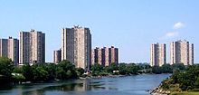
[54] Immediately downstream, the river widens into an estuary, with tidal flats on its eastern shore and housing projects on its west, with small Goose Island just offshore.
Another 0.3 mi (0.48 km) downstream from the parkway, the Pelham Bay Bridge carries Amtrak's Northeast Corridor passenger service over the river.
[5][9] The terrain in the watershed is generally level and densely developed either as urban multiple-unit housing, suburban single-family homes or intense commercial and industrial use.
The northernmost active terminal, Sprague Energy located at 100 Canal St. in Mount Vernon, still accepts barges of heating oil, ULSD, and biodiesel blends daily.
The northernmost dock in the dredged project, Imperia Brothers Inc., has not been able to accept a scow of aggregates since 2007 due to the silt build-up.
In March 1934 a tug struck a rock while navigating an ice field under the Pelham Bay Bridge and began leaking; a rowboat was used to evacuate the crew of five before it sank.
[58] The United States Coast Guard closed the river to navigation fora a day after an April 1967 accident, when a tanker began leaking gasoline after striking a submerged obstacle.
[citation needed] The New Rochelle Water Company dammed the Hutchinson River at three places between 1886 and 1907, creating three reservoirs at the northern end of the community.
The Westchester County Park Commission purchased the reservoirs and the surrounding water shed property in 1927, for parkland and parkway purposes.
[62] The town faced several fines by 2017, having not taken action to mitigate pollution for two decades,[63] and in 2020, received a federal court order calling for compliance with the Clean Water Act.
[61] In 2019, the New York environmental organization Riverkeeper sued J. Bass & Son Inc., a scrap metal company based in Mount Vernon, for polluting the river under the Clean Water Act.
[64] A project to repair the broken sewage collection line in Mount Vernon, funded by the New York State Department of Environmental Conservation, was underway as of May 2023.