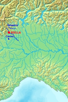
Hydrography of the Biella region
[6] Before the formation of the ridge and more generally of the Ivrea Morainic Amphitheatre, deposited at the outlet of the Aosta Valley during the last glaciations, the hydrographic network of the area that today constitutes the Province of Biella must have been completely different from the present one.
[3] Paleogeographical research (in particular by geologists Francesco Carraro[7] and Franco Gianotti[8]) in fact shows how in ancient times the Cervo, after leaving the alpine valley of the same name, headed decisively southward to flow into the Dora Baltea roughly where Verrone stands today.
[9] Nevertheless, the deposition of the enormous moraine apparatus of the Serra and of sedimentary beds to the east of it changed this configuration and gradually diverted the course of the Cervo eastward, eventually leading it to flow into the Sesia.
Sediments transported by the Balteo Glacier also barred the way towards the Dora to the current right tributaries of the Cervo itself, thus also conveying their waters towards the Sesia basin.
[3] The deep incision in the rocky substrate produced by the ancient course of the Cervo River and preserved below the present sedimentary blanket is of considerable importance today because of the aquifers it contains, which can potentially be exploited for potable water use.
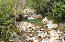
[3] The water supply provided by melting winter snow accumulation (often abundant in the upper Cervo or Sessera valleys[5]) is exhausted relatively quickly during the spring due to the lower elevation reached by the Biellese Alps compared to the other Piedmont mountain ranges.
The impact on the territory of these values, already very high in themselves, was then aggravated by the fact that the rain, instead of being evenly distributed over the two days, was concentrated in the night between Saturday and Sunday.
The latter, with a surface area of almost 6 km2, is in fact the third largest lake in Piedmont and is an important tourist hub with numerous accommodation and recreational facilities located on its shores.
The lake is located on the border with the Province of Turin (in fact, about 1/6 of its surface area falls within the municipality of Azeglio); a public boat line connects the main towns along the coast.
[19] They are located in the mountainous belt of the province and occupy the small basins left by the cirque glaciers present in the Biellese Alps during the glacial episodes of the Middle and Upper Pleistocene.
The main lakes of this type are: They are located in depressions included between the moraine ridges abandoned during the episodes of advance and retreat of the huge glacier that in the Pleistocene ran through the valley of the Dora Baltea.
[22] In particular, the remains of a Bronze Age village and two ancient monoxyle pirogues, i.e., built from a single tree trunk, have been found near Lake Bertignano; the boats are preserved in the Museum of Antiquities in Turin.
In particular, the Ponte Vittorio reservoir, whose construction dates back to 1953, was created to serve the numerous industrial users in the Strona di Mosso Valley.
For centuries through this system of canals there has been a transfer to the Biellese and Vercellese areas of water resources from the Dora Baltea,[4] the flow of which remains substantial even during the summer thanks to the contribution provided by the snowfields and glaciers of the Valdaostan Alps.
[12] The following table shows a series of data on the watersheds of Biella's main streams, taken from the Water Protection Plan adopted by the Piedmont Region.
The former depends on the lithological and tectonic characteristics of the area under consideration (rock erodibility, slope gradient, presence of structural fractures, etc.)
[14] On the other hand, as far as estimating the solid transport capacity of river courses is concerned, it is necessary to consider not only the magnitude and duration of the watercourse's flow rates, but also the physical characteristics of its riverbed (slope, width, roughness, tortuosity, grain size of materials).
[32] The following table provides an estimate of the annual solid transport capacity of the two main streams in Biella and, for comparison, shows the same data referring to the Sesia River.
From the available data, it appears that the overall situation on the Elvo is fairly close to the equilibrium point, and that instead along the Cervo River channel erosion tends to predominate over deposition.
This second mineral water, which qualifies as the lightest in Europe,[35] is instead collected and bottled in the municipality of Graglia by Società Lauretana S.p.a.[36] The streams draining the Bessa area are known, as are other Piedmontese watercourses such as the Orco, for the presence of bits of gold in the bed sands.
[18] During periods when the flow is sufficiently high, however, it is possible to go down some streams by canoe or rafting, including the Sessera, the Strona di Postua,[41] and the Cervo.
The environmental status of streams in the Biellese region is generally satisfactory in the upland section but worsens considerably in the more anthropized hillside areas due to emissions from civil and industrial sources.
[5] Even in the lowlands, due to water shortages caused by withdrawal for agricultural use and the presence of pesticide residues, the environmental status of Biella's streams generally remains unsatisfactory.