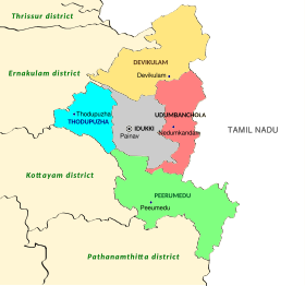
Idukki district
The 2,695 metres (8,842 ft) high peak of Anamudi, which is also the highest point of elevation in India outside the Himalayas, lies in the northern portion of the district of Idukki.
[12] The temples and other older buildings in the High Range and the surrounding regions in Idukki have significant influences from the medieval era Tamil-Pandyan architectural styles.
[13] Located on the highest point of elevation on the Peninsular India, the Cardamom Hills and its surrounding regions were inhabited by human beings during the Megalithic age itself.
[12] The Megalithic monuments found from Idukki show numerous similarities with the contemporary remnants those discovered from Deccan plateau and other parts of the South India.
[14] Tribal people who were in contact with Tamil culture came to Idukki, from present day Coimbatore, Madurai and Ramanathapuram districts, as evidenced by their language, customs and art forms.
There are 33 tribal sanctuaries in Idukki including Venmani, Mullaringad, Nadukani, Kurukanadu, Koovakandam, Kannampadi, Muthampadi, East Mattucutta, Vellall, Memarikudi, Poovantikudi.
In later times, the people who came to Poovanthikudi,Ayyappancoil who fled from the forest where the Mullaperiyar Dam is located, they left agriculture with the migration of the Britishers, Tamils and the Malayalis.
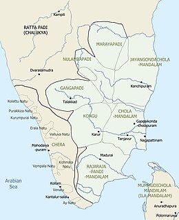
[12] According to those works, early members of the Chera dynasty (first few centuries of the Common Era) had their original headquarters in a region called Kuzhumur at Kuttanad in the ancient Tamilakam and were sometimes known as the Kuttuvans.
[12] The province Kuttanad in the ancient kingdom of Keralaputras included the modern-day districts of Idukki, Ernakulam, Kottayam, and parts of Alappuzha, which could be broadly defined as the region between the rivers Periyar and Pamba.
[12] It was during the reign of Uthiyan Cheralathan (105–130 CE) that the Chera dynasty began to expand towards the northern and the eastern regions of Kuttanad by conquering the provinces of Kudanadu and Kongu Nadu.
[12] Afterwards the dynasty got split into three branches and fixed their capitals at Muziris, Tyndis, and Caroura, respectively, as seen in the ancient Greco-Roman travelogues as well as the Old Tamil literary works of the Sangam period.
The High Range region, which lies to the east of Keezhmalanadu, was possibly included in two provinces namely Nantuzhanadu[16] and Vempolinadu (known as Bimbali Desam in Sanskrit).
[12] Vadakkumkur was the northern branch of the erstwhile province of Vempolinadu which attained political autonomy in 1102 CE after the collapse of the Chera Perumals of Mahodayapuram.
[12] Vadakkumkur Raja was a part of the combined military alliance formed by the kingdoms of Odanad (Kayamkulam), Thekkumkur, and Cochin against the expansion of Travancore into the northern territories.
[12] It is presumed that a major portion of the High Range region in Idukki district belonged to the Thekkumkur dynasty just after the collapse the Chera Perumals of Mahodayapuram.
[12] The Dutch East India Company was attracted by enormous growth of black pepper in the High Ranges of the Idukki district.
[12] Upon the failure in the battle, Manavikrama appointed his brother Maravarman Sreevallabha as the monarch of the Pandya dynasty and left Madurai with his family and some of his trusted servants.
[17] The proclamation, issued on Malayalam Era 15 Medam 997 (which corresponds to CE 28 April 1822), entrusted Tamil workers from neighbouring districts of the Madras Presidency with harvesting cardamom in the region.
[17] The Kannan Devan Hills on the High Range region were given on lease on 11 July 1877 by the ruler of the Poonjar dynasty to John Daniel Munroe from London and for tea plantations.
Tradition states that Colonel Arthur Wellesley, 1st Duke of Wellington, was the first British man to pass through Munnar during Tipu Sultan's campaign into Travancore in the last decades of the 18th century CE, but this is unsubstantiated.
[20] Munroe, Henry Turn, and his half-brother A W Turner, obtained ownership of the Cardamom Hills from the Raja of Travancore and began clearing forest around Devikulam in 1879.
The former Kundala Valley Railway through Munnar, established in 1902, was destroyed by the Great flood of 99 that occurred in 1924 across the modern-day state of Kerala.
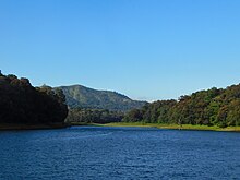
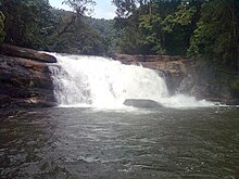
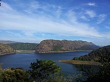
[32] The Idukki district forms a high altitude plateau with rugged mountainous terrain, several river valleys and deep gorges.
The Pambar river valley (Marayoor, Keezhanthoor) forms an eastern sloping rain shadow region of the Western Ghats.
It is highly vulnerable to floods and drought and is considered a climate change hotspot in Kerala, along with the districts of Alappuzha, Palakkad, and Wayanad.
[8] The aboriginal tribes in the district speak their own dialects such as Malavedan, Malaryan, Muthuvan, and Paliyan, which are closely related to the Malayalam and Tamil.
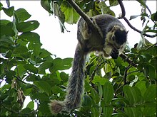
[47] Twenty-six species of mammals have been recorded in the park including the largest surviving population of Nilgiri tahr,[48] estimated at 750 individuals.
Endemic butterflies confined to the shola-grass land ecosystem like the red disk bushbrown and Palni four-wing are among the 101 species in the park.
[53] Kurinjimala Sanctuary protects the approximately 32 km2 core habitat of the endangered Neelakurinji plant in Kottakamboor and Vattavada villages in Devikulam Taluk, Idukki district of Kerala State in South India.
Kovilmala is the headquarters of Mannan community who preserves certain customs, traditions, and form of governance, making them a unique tribal unit.