Iglesias, Sardinia
Iglesias (Italian pronunciation: [iˈɡlɛːzjas], locally [iˈɡlezjas] ⓘ; from Spanish: [iˈɣlesjas]; Sardinian: Igrèsias[2]) is a comune and city in the province of South Sardinia, Italy.
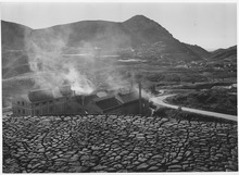
At an elevation of 190 metres (620 ft) in the hills of southwestern Sardinia, it was the centre of a mining district from which lead, zinc, and silver were extracted.
Other pre-Nuragic finds attributed to the Monte Claro, Bell Beaker and Bonnanaro cultures were discovered in nearby caves,[3] followed by evidence of a Nuragic, Punic and Roman presence.
[4] The count took advantage of the region's silver resources and established a city: Latin: Villa Ecclesiae (Churchville), renovating old buildings and constructing new ones.
[5] Guelfo, hostile to the Pisan government, tried to seize one-sixth of the former Judicate of Cagliari (Sulcis) owned by Gherardo della Gherardesca's heirs and occupied Villamassargia's Castle of Gioiosa Guardia.
Pisa's response was swift; in 1295 republican troops, supported by the forces of Marianus II of Arborea, attacked Villa di Chiesa.
[6] The city, primarily inhabited by Sardinians and Pisans, also housed other communities from Tuscany and the Italian Peninsula, Corsica[7] and Germany.
During the transition from Pisan to Aragonese rule, 6,000–7,000 people lived in Villa di Chiesa; however, the Black Plague of 1348 killed much of the population.
Many miners, workers and technicians from elsewhere on Sardinia and northern Italy settled in the city, whose population increased from 5,000 to 6,000 during the 1850s to about 20,000 in the early 20th century.
The square castle's northern and eastern sides, built in courses of stone alternating with brick, seem to adhere to the original medieval plan and confer solidity.
Construction of the Santa Chiara Cathedral was an initiative for demographic and urban development undertaken by the Donoratico della Gherardesca family.
The cathedral's façade, with a pitched roof, is divided into two parts by a horizontal, moulded cornice at the level of the architrave over the doorway.
[11] The Church of San Francesco has a gabled façade with smooth stonework; the door in its centre is surmounted by a rose window and flanked by two side oculi.
The Church of Santa Maria di Valverde is outside the town walls and nearly contemporary with the cathedral, with similar style and structure.
Pisan walls surround the city's historic centre, following its irregular outline and using its incline with the Castle of Salvaterra.
Although urban expansion led to the incorporation of several stretches of wall into private homes, the remnants retain the features of medieval military fortifications: blind façades of mixed stones arranged in horizontal courses to create an uneven mass, providing resistance to attack.
The council meeting room was decorated during the 1920s in a design by Sardinian sculptor Francesco Ciusa and painter and illustrator Remo Branca.
The Sanctuary of Madonna delle Grazie dates to the 12th and 13th centuries, and was initially dedicated to the Cagliari martyr San Saturno.
The church nave is divided into six bays by pointed trachyte arches supporting a wooden vault with exposed beams.
The museum was conceived in 1998 by a group of mining men who wanted a tangible reminder of their origins so the history of their land would not be forgotten.
The Belgian Vieille Montagne company appointed engineer Cesare Vecelli to conduct a planning study from 1922 to 1924 of reducing the cost of transporting ore from the mine to the port.
When mining activity in the region began is uncertain, but "Monte Paone" was mentioned in the 1324 will of Berto da San Miniato (a trader from Pisa).
Its simple facade is surmounted by a tympanum; an oculus in the centre has coloured glass forming an image of Saint Joseph and the child Jesus.
Decorative features added after 1774, when the Jesuits left the city after the suppression of their order, contrast with the church's general sobriety; its paintings date to the early 20th century, in fact.
The reconstruction project was planned by engineer Luigi Degrossi in 1901 with material recovered from the original church, including slate slabs for the inside flooring.
Inside is a fairly-small, quadrangular room with four pointed arches marking four bays and terminating in a large, horseshoe-shaped apse.
The monastery includes wings developed according to the model of open ground-floor loggias, arranged around a green area accessed through broad arches of pink trachyte.
The cemetery covers the area between Via Cappuccini and Su Pardu, following a plan with intersecting avenues marking squares.
The entrance from Via Cappuccini separates the sober Liberty-style flowers and Masonic symbols on one side from memorials to the war dead on the other.
A renovation of Piazza Oberdan was proposed in April 1953; pavement slabs were laid and flower beds were arranged around the monument, which was fenced off with chains.