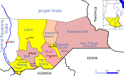
Ikotos County
Years of civil war have made violence commonplace: most people have experienced the murder of a close family member.
[4] The county contains the Imatong mountains in their entirety, which includes the highest peak in Sudan, Mount Hinati at 3,187 metres (10,456 ft).
The mountains rise steeply from the surrounding plains, which are at an elevation of 1,000 metres (3,300 ft) on the South Sudan-Uganda border, sloping down gradually to the north.
These plains are crossed by many streams, separated by low, rounded ridges, and dotted with small gneiss hills, outliers of the main mountain range.
The areas to the east and southeast are in the rain shadow of the mountains, with dry arid grassland or deciduous or semi-evergreen bush.
[8] The county's area is home to the Ketebo, Dongotono, Imotong, Logir, Otuho, Lango: Lokwa & Lorwama.
[9] The Ketebo live in Bira which include Lotome, Nakoringole, Lofus, Ateda/ Madiel, Lorum, Napeyase, Longairo, Osisi, Toomodo, Okosio, Ofi, Lobila Tome, Kamulach, Kalabe, Narus Bokolore, Lorife, Lonyili, Irobi, Lojilingare, etc.
while the Dongotona live in dense settlements, cultivate sorghum, groundnuts, simsim, telebun, and sweet potatoes, and keep large herds of cattle, sheep and goats.
[10] Cattle play a central role in social life, used in contracting marriages and performing rituals, and exchanged as gifts.
Crops are generally rain-fed, with no irrigation, making them vulnerable to reduced rainfall or drought in either of the two growing seasons.
[7] Emin Pasha was cut off from Egypt by the revolt of Muhammad Ahmad in the northern Sudan, which began in 1881, and in 1885 withdrew to the south.
In 1929 the botanist Thomas Ford Chipp, then deputy director of the Royal Botanic Gardens at Kew, reached the peak of Kinyeti.
Sudan became independent in 1956, but a year earlier civil disturbances had broken out in the southern regions that did not want to come under control of the Arab-dominated government in Khartoum.
[15] The influx of SPLA fighters and government troops led to a sharp rise in the number of guns available, and to their use in cattle raids and murders.
[3] The security problem was compounded by the presence of the Ugandan rebel group, the Lord's Resistance Army (LRA), notorious for killing, looting for food, destroying property and abducting women and children.
[18] In May 2003 the Imatong and Ikwoto districts, then in Torit County, reported 178 suspected cases of Yellow Fever and 27 deaths.
[19] On a positive note, during this period Norwegian Church Aid made a significant contribution with the Ikwoto County Education Centre, which trained 120 teachers in 2004 and 2005.
They signed a declaration committing to eliminate all obstacles to the unity of the six Lango tribes and set up a task force to implement recommendations for keeping the peace.
Economic growth has been minimal, even compared to neighboring counties such as Budi, and many people have failed to obtain a formal education.
[2] In 2007 the Lutheran World Federation (LWF) implemented an emergency response project that provided food, agricultural tools, crop seeds, and non-food items to refugee returnees, Internally Displaced People (IDPs) and the resident communities in Ikotos country.
The leaders also passed a resolution to eliminate cattle rustling, in part by launching vocational training institutions for youths of the county.