Ilú–Tramen Massif
[1] It is the northernmost member of the Eastern Tepuis chain and comprises two major plateaus: the larger Ilú-tepui (also spelled Uru) to the south and Tramen-tepui to the north, all close to the border with neighboring Guyana.
However, maps prepared by Emilio Pérez and others including, the Diccionario Geografico del Estado Bolivar, the Cartografia Nacional 1999 as well as Flora of the Venezuelan Guayana[3] name the mountain Tramen-tepui.
Currently in 2017, a team of Pemón led by Antonio Hitcher is trying to secure the traditional toponym expressed in Arekuna, Kamarakoto and Taurepan.
Previous expeditions to the Ilu-Tramen Massif include those of Basset Maguire, botanist and Director of the New York Botanical Garden, in the early 1950s and Guyana mountaineer, Adrian Thompson.
[4] A record by Stephen Platt and Scharlie Wright from their expedition in 1981 describe the first successful attempt of summiting Tramen-tepui (referred to as Ilu-tepui by the author).
[2] In 1987 and 1988 expeditions to the upper valley conjoining Ilu-tepui and Tramen-tepui slopes were organized by teams of American and German botanists, with the main aim of studying Heliamphora ionasi populations in-situ.
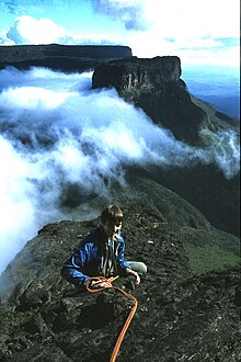
The climbing party comprised Polish photographer Marek Arcimowicz and Venezuelan climbers Alberto Raho and Mario Osorio.
The expedition was led by Michał Kochańczyk, and accompanied by biologist Izabela Stachowicz, a biology graduate from the Jagiellonian University.
They failed on their first attempt in heavy rain trying to climb the west face directly below the huge chasm that splits the upper wall.
They crossed the half-mile rock platform, leaving stone cairns and upturned pitcher plants every few metres to mark the route in case the swirling cloud descended.