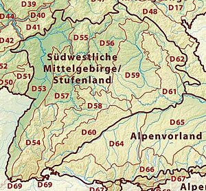
Iller-Lech Plateau
In the east the Iller-Lech Plateau borders on the Lower Bavarian Upland and Isar-Inn Gravel Plateaus (unit D65 on the map).
North of Augsburg its eastern boundary runs roughly parallel to state road 2035 (Augsburg-Pöttmes-Neuburg an der Donau), south of Augsburg east of the Lech, roughly between Mering, Geltendorf and Schongau.
To the south the Southern Alpine Foreland (D66 on the map) borders on the Iller-Lech Plateau.
The boundary between these two natural regions is partly formed by the terminal moraines of the Würm glaciation.
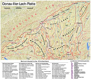
For the exact location and boundaries of the individual sub-divisions: see the BfN's map Landscapes in Germany (http://www.bfn.de/geoinfo/landscapes/ Archived 2016-03-03 at the Wayback Machine) Region between Danube, Mühlingen, Pfullendorf, Ostrach, Bad Saulgau and Federsee Old Drift landscape dominated by the Rift and Mindel glaciation of the Rhine Glacier Gently rolling hill country Danube Valley between Mengen and Ulm, region between Herbertingen and Bad Saulgau, Riss Valley from Schemmerhofen to where it joins the Danube Flat Much grassland and arable farming The Riss valley from the south which merges into the Danube valley is more marshy that the Danube valley The Federsee lies in the middle of this natural region near Bad Buchau Flat Because the lake has since been filled with sediment and gravel in places, the natural dammed lake was once much large Region between Danube, Riss and, roughly, the B 312 Tertiary Hill Country, in places however also ice age gravel deposits Hilly Agricultural land use predominates because the soils are loamy and fertile The Bussen is in this region Riss glaciation terminal or ground moraine landscape Undulating The Wurzach Ried is in the east of the Riss-Aitrach Plateau Region between Senden, Aichstetten, Ochsenhausen and Laupheim Rolling hills Landscape still not very dissected Region between Neu-Ulm, Senden and Laupheim Comprises various old gravel terraces along the valleys of the Riss and Danube, formed during the Riss glaciation Intensive arable land use The south is less dissected by valleys than the north Iller Valley from Altusried and Dietmannsried to where it joins the Danube at Neu-Ulm Broad valley filled by large quantities of gravel during and after the ice ages Flat The north is used more for arable farming; the south more as grassland Large fen plain by the Danube between Neu-Ulm and Donauwörth Würm Ice Age formed, partly boggy gravel plain Flat Used predominately for grassland and arable land, which has largely displaced the natural reed beds Many gravel pits Gently undulating glacial gravels divided into interfluvial ridges and gravel plateaus by river systems flowing from south to north Gently undulating Gently undulating The Stauden Plateau, Zusam Plateau and Stauffenberg region together form the Augsburg-Westliche Wälder Nature Park Flat Between Gennach and Lech, south of Denklingen Flat to hilly Pure forest landscape (mainly pine forests) Lech Valley from Schongau to Augsburg and from Augsburg to where it joins the Danube Hilly Landscape rising from north to south Gently undulating Arable land predominates Together with the Fürstenfeldbruck hill country forms one of the semi-circular Old Drift moraines in front of the adjoining Ammer-Loisach Hills