Illinois Country
Explored in 1673 from Green Bay to the Arkansas River by the Canadien expedition of Louis Jolliet and Jacques Marquette, the area was claimed by France.
It was settled primarily from the Pays d'en Haut in the context of the fur trade, and in the establishment of missions from Canada by French Catholic religious orders.
[6] By the mid-18th century, major settlements included Cahokia, Kaskaskia, Chartres, Saint Philippe, and Prairie du Rocher, all on the east side of the Mississippi in present-day Illinois; and Ste.
The Spanish-occupied portion of Illinois Country west of the Mississippi was acquired by the United States from France in the Louisiana Purchase of 1803.
Early French missionaries and traders referred to the area southwest and southeast of the lake, including much of the upper Mississippi Valley, by this name.
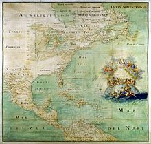
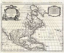
A royal ordinance of 1722—following the transfer of the Illinois Country's governance from Canada to Louisiana—may have featured the broadest definition of the region, making it coterminous with Upper Louisiana: all land claimed by France south of the Great Lakes and north of the mouth of the Ohio River, including both banks of the Mississippi as well as the lower Missouri Valley.
[8]) As part of a general report on conditions in the newly conquered lands, Gen. Thomas Gage, then commandant at Montreal, explained in 1762 that, although the boundary between Louisiana and Canada was not exact, it was understood that the upper Mississippi above the mouth of the Illinois was in Canadian trading territory.
Joseph de La Roche Daillon reached an oil spring at the northeasternmost fringe of the Mississippi River basin during his 1627 missionary journey.
In 1669–70, Father Jacques Marquette, a missionary in French Canada, was at a mission station on Lake Superior, when he met native traders from the Illinois Confederation.
[10][11] By 1714, the principal European, non-native inhabitants were Canadien fur traders, missionaries and soldiers, dealing with Native Americans, particularly the group known as the Kaskaskia.
[13][14] French explorers led by René-Robert Cavelier, Sieur de La Salle built Fort St. Louis on a large butte by the Illinois River in the winter of 1682.
Accompanying the French to the region were allied members of several native tribes from eastern areas, who integrated with the Kaskaskia: the Miami, Shawnee, and Mahican.
Hoping to make a fortune mining precious metals in the area, the company with a military contingent sent from New Orleans built a fort to protect its interests.
The nearby settlement of Prairie du Rocher, Illinois, was founded by French-Canadian colonists in 1722, a few miles inland from the fort.
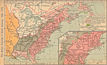
The British Crown declared almost all the land between the Appalachian Mountains and the Mississippi River from Florida to Newfoundland a Native American territory called the Indian Reserve following the Royal Proclamation of 1763.
The British softened the initial expulsion order and offered the Canadien inhabitants the same rights and privileges enjoyed under French rule.
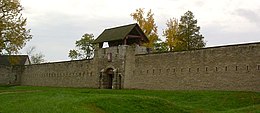
Chartres' ruined but intact magazine is considered the oldest surviving European structure in Illinois and was reconstructed in the 20th century, with much of the rest of the Fort.
[17] After the port of New Orleans, along the Mississippi River to the south, was founded in 1718, more African slaves were imported to the Illinois Country for use as agricultural and mining laborers.
[18] Following the British occupation of the east bank of the Mississippi in 1765, some Canadien settlers remained in the area, while others crossed the river, forming new settlements such as St. Louis.
[21] During the Revolutionary War, General George Rogers Clark took possession of the part of the Illinois Country east of the Mississippi for Virginia.
For their assistance to General Clark in the war, settled Canadien and Indian residents of Illinois Country were given full citizenship.
Under the Northwest Ordinance and many subsequent treaties and acts of Congress, the Canadien and Indian residents of Vincennes and Kaskaskia were granted specific exemptions, as they had declared themselves citizens of Virginia.