Roads in India
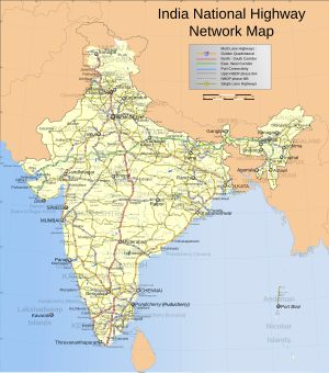
As of 31 December 2023, India had completed and placed into use over 35,000 kilometres (22,000 mi) of four or more lane highways connecting many of its major manufacturing, commercial and cultural centres.
[update][3] The first evidence of road development in the Indian subcontinent can be traced back to approximately around 2800 BC in the ancient cities of Harrapa and Mohenjodaro of the Indus Valley civilization.
Ruling emperors and monarchs of ancient and medieval India continued to construct roads to connect the cities.
[8] In the 1830s, the British East India Company started a programme of metalled road construction (a.k.a.
The Grand Trunk Road – from Calcutta, through Delhi to Peshawar – was rebuilt at a cost of £1,000 per mile; roads from Bombay to Pune, Bombay to Agra and Bombay to Madras were constructed; and a Public Works Department and the Indian Institute of Technology Roorkee were founded, to train and employ local surveyors, engineers and overseers, to perform the work, and to maintain the roads.
[11] In 1956, a Highways Act was passed, and a second twenty-year plan proposed for the period 1961–1981, with the ambition of doubling road density to 32 km per 100 km2.
[11] In 1988, an autonomous entity called the National Highways Authority of India (NHAI) was established by an Act of Parliament and came into existence on 15 June 1989.
The Act empowered NHAI to develop, maintain and manage India's road network through National Highways.
[12] In 1998, National Highways Development Project (NHDP) was started by the then Prime Minister Atal Bihari Vajpayee.
The flagship project of the NHDP is the Golden Quadrilateral, a total of 5,846 kilometres (3,633 mi) of four-to-six-lane highways connecting the four major cities of Delhi, Mumbai, Chennai and Kolkata.
[13][14] Another important road project of the NHDP is the 7,142-kilometre (4,438 mi) four-to-six-lane North–South and East–West Corridor, comprising national highways connecting four extreme points of the country.
[16] The National Highways and Infrastructure Development Corporation Limited (NHIDCL) is a Public Sector Enterprise(PSE) created by the Ministry of Road Transport and Highways (MoRTH), Government of India in the year 2014 to build highways in technical challenging and high altitude regions of the Northeast India, Uttarakhand, Jammu and Kashmir, Ladakh and the Andaman & Nicobar Islands.
It has the task to implement the Special Accelerated Road Development Programme for North Eastern Region (SARDP-NE) in National Highways portion.
Bharatmala Phase I plans to construct 34,800 kilometres (21,600 mi) of highways (including the remaining projects that were under NHDP) by 2021–22, at an estimated cost of ₹535,000 crore (US$62 billion).
[27][28] As per NHAI and Indian Roads Congress, expressways are access controlled highways with a divided carriageway, designed for high speed vehicular movement and heavy traffic.
The NHAI has been undertaking developmental activities under the National Highways Development Project (NHDP) in five phases.
The NHAI is also responsible for implementing other projects on National Highways, primarily road connectivity to major ports in India.
The Golden Quadrilateral and North–South and East–West Corridor were major ongoing highway development projects in India.
[45] District Roads in India are approximately 632,154 kilometres (392,802 mi), of which 14.80% of the total length was surfaced.
In some parts of India, the government has attempted to manage the programme directly as a local social spending program.
The effort has aimed to build all-season single-lane asphalted roads to connect India's rural and remote areas.