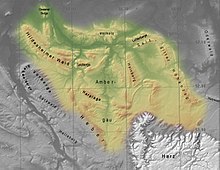
Innerste Uplands
Its central and southern areas are dominated by the Ambergau, a depression dissected by the Nette, a tributary of the Innerste.
In and around the Innerste Uplands there are the following clearly defined ridges, most of which are cuestas and some of which lie on the boundary with neighbouring landscape regions (listed in alphabetical order): Giesen Hills, Hainberg, Harplage, Heber, Hildesheim Forest, Salzgitter Ridge (including the Lichtenberge), Sauberge and Vorholz.
The rivers run through gently rolling depressions, covered with a thick layer of loess; this includes the basin of the Ambergau.
Also part of the landscape are quarries or open-cast mines, nowadays largely closed and sometimes filled with water, in which Keuper sandstone was extracted during the Middle Ages.
They are, in order of height: The highest elevation in the Innerste Uplands is the 359 m high Griesberg in the Hildesheim Forest.