Insula (Roman city)
[2][3] The latter type of Insulae were known to be prone to fire and rife with disease.
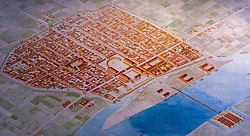
[4] A standard Roman city plan[5] was based on a grid of orthogonal (laid out on right angles) streets.
[6] It was founded on ancient Greek city models, described by Hippodamus.
The streets of each city were designated the decumani (east–west-oriented) and cardines (north–south).
The principal streets, the decumanus maximus and cardo maximus, intersected at or close to the forum, around which the most important public buildings were sited.