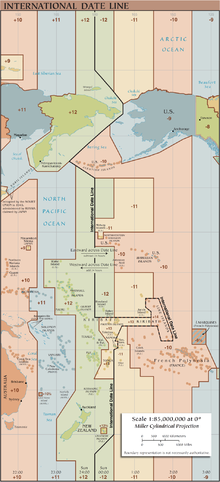
International Date Line
This has made it difficult for cartographers to agree on its precise course and has allowed countries through whose waters it passes to move it at times for their convenience.
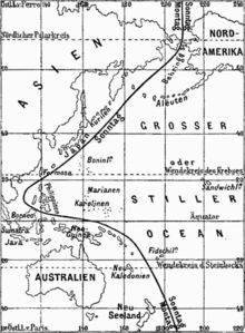
The 14th century Arab geographer Abulfeda predicted that circumnavigators would accumulate a one-day offset to the local date.
After sailing westward around the world from Spain, the expedition called at Cape Verde for provisions on Wednesday, 9 July 1522 (ship's time).
[3] Cardinal Gasparo Contarini, the Venetian ambassador to Spain, was the first European to give a correct explanation of the discrepancy.
Proceeding from north to south, the first deviation of the IDL from 180° is to pass to the east of Wrangel Island and the Chukchi Peninsula, the easternmost part of Russian Siberia.
[citation needed] A 1994 realignment of the IDL made Caroline Island one of the first points of land on Earth to reach January 1, 2000, on the calendar (UTC+14:00).
Around the June solstice, the first area would be any place within the Kamchatka Time Zone (UTC+12:00) that is far enough north to experience midnight sun on the given date.
At the equinoxes, the first place to see daylight would be the uninhabited Millennium Island in Kiribati, which is the easternmost land located west of the IDL.
[citation needed] Near the December solstice, the first places would be Antarctic research stations using New Zealand Time (UTC+13:00) during summer that experience midnight sun.
[9] There are two ways time zones and thereby the location of the International Date Line are determined, one on land and adjacent territorial waters, and the other on open seas.
[citation needed] All nations unilaterally determine their standard time zones, applicable only on land and adjacent territorial waters.
[citation needed] The nautical date line, not the same as the IDL, is a de jure construction determined by international agreement.
It follows the 180° meridian except where it is interrupted by territorial waters adjacent to land, forming gaps—it is a pole-to-pole dashed line.
As part of New Spain, the Philippines had its most important communication with Acapulco in Mexico, so it was on the eastern side of the IDL despite being on the western edge of the Pacific Ocean.
[16][17] European publications were generally unaware of this change until the early 1890s, so they erroneously gave the International Date Line a large western bulge for the next half century.
In 1867, the United States purchased Russian America and moved the territory to the east side of the International Date Line.
[27] Samoa made the change because Australia and New Zealand have become its biggest trading partners, and also have large communities of expatriates.
[30] Kwajalein atoll, like the rest of the Marshall Islands, passed from Spanish to German to Japanese control during the nineteenth and twentieth centuries.
Although Kwajalein formally became part of the Trust Territory of the Pacific Islands with the rest of the Marshalls after World War II, the United States established a military installation there.
To eliminate this anomaly, Kiribati introduced a change of date for its eastern half by removing Saturday, 31 December 1994 from its calendar.
Christmas for example, is celebrated on 25 December (according to either the Gregorian or the Julian calendar, depending upon which of the two is used by the particular church) as that date falls in countries located on either side of the IDL.
[33][34] Most Seventh Day Adventists in Samoa planned to observe Sabbath on Sunday after Samoa's crossing the IDL in December 2011, but SDA groups in Samatau village and other places (approximately 300 members) decided to accept the IDL adjustment and observe the Sabbath on Saturday.
For example, residents of the Jewish communities of Japan,[41] New Zealand,[42] Hawaii,[43] and French Polynesia[44] all observe Shabbat on local Saturday.
For this reason, some authorities rule that certain aspects of Sabbath observance are required on Sunday (in Japan and New Zealand) or Friday (in Hawaii and French Polynesia) in addition to Saturday.
[39][40] For individuals crossing the IDL, the change of calendar date influences some aspects of practice under Jewish law.
Yet other aspects depend on an individual's experience of sunsets and sunrises to count days, notwithstanding the calendar date.
Unable to swim, the protagonist indulges in increasingly imaginative speculation regarding the physical, metaphysical and religious importance of the IDL.
However, the journey suffers a series of delays and when Fogg reaches London, he believes it is 8:50 p.m. on Saturday, 21 December and that he has lost the wager by a margin of only five minutes.
Verne explains: In journeying eastward he [Fogg] had gone towards the sun, and the days therefore diminished for him as many times four minutes as he crossed degrees in this direction.
But a de facto date line did exist since the U.K., India, and the U.S. had the same calendar with different local times, and he should have noticed when he arrived in the U.S. that the local date was not the same as in his diary (his servant Jean Passepartout kept his watch set to London time, despite the clues from his surroundings).