Interstate 19
I-19 travels from Nogales, roughly 90 meters (300 ft) from the Mexican border, to Tucson, at I-10.
Having a total length of just over 102 kilometers (63 mi), I-19 is the eighth-shortest primary (two-digit) Interstate Highway in the contiguous 48 states, where only I-86 (Idaho), I-11 (Nevada), I-2 (Texas), I-42 (North Carolina), I-14 (Texas), I-97 (Maryland), and I-87 (North Carolina) are shorter.
While the highway is short, it is a very important corridor, serving as a fast route from Tucson and Phoenix (via I-10) to the Mexican border.
In Nogales, the southern terminus of I-19 is at West Crawford Street, adjacent to the international port of entry, and southbound travelers can continue into Heroica Nogales, Mexico, via state-maintained surface roads, and connect with Federal Highway 15 (Fed.
[3] Starting from the southern terminus at kilometer post 0 (not milepost 0), I-19 initially heads briefly south then west on surface streets, navigating its way through the town of Nogales for 0.32 kilometers (0.2 mi) before becoming an Interstate-grade freeway and making the turn to head north toward Tucson.
The interchange with SR 189 at exit 4 both serves to funnel traffic so as to bypass around Nogales and Heroica Nogales for travelers bound to or from Hermosillo or Mexico City and provides for the continuous flow of freight and truck traffic through the larger Nogales-Mariposa Port of Entry to Fed.
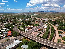
[4] After exiting Nogales to the north, I-19 passes near and around a series of sparsely-populated towns and retirement communities along the banks of the Santa Cruz River, including Rio Rico, Tubac, Amado, Green Valley, and Sahuarita.
[3] Just before entering Tucson, I-19 passes through the eastern section of the San Xavier Indian Reservation where it makes its only crossing of the Santa Cruz River.
On advance guide signs, the metric unit expressions "km" and "m" were placed on the baseline where "MILES" would otherwise have gone but were sized so that their lowercase loop height matched the uppercase letter height of "MILES" on customary-unit signs.
The exception was a handful of advance guide signs for the SR 86 (Ajo Way) exit, which used "KM" (in uppercase, contrary to SI nomenclature) on the same baseline and at the same letter height as "MILES".
Notwithstanding the metric legends, the signing plans were dimensioned entirely in feet and inches.
[7] In 1999, ADOT awarded two contracts (administered as a single construction project) to renew the signs along the full length of I-19.
As of 2010[update], the remainder of the project has been stalled due to local opposition, particularly from businesses that would have to change their directions.
[11] A reconstruction project at the Interstate's northern terminus with I-10 in Tucson (at the interchange commonly called the Crossing) began in 2002 and was completed in August 2004.
[13] Future plans include expansion to up to five lanes in each direction by 2030 from the crossing with I-10 to San Xavier Road.
began at I-19 exit 69 in Green Valley at West Duval Mine Road and South Nogales Highway.
followed Nogales Highway north through unincorporated Pima County and Sahuarita into Tucson.