Interstate 287
[2] From this point, it heads west as an eight-lane freeway through suburban areas, soon reaching an interchange with US 1 that also has access to County Route 531 (CR 531) in the southbound direction.
Past this point, the road turns more to the northwest and passes under Conrail Shared Assets Operations's Bonhamtown Industrial Track line and a railroad spur before it comes to the junction with Route 27 (Lincoln Highway).
[2][3] Following Route 27, I-287 narrows to six lanes and passes over Amtrak's Northeast Corridor as it continues to a southbound exit and northbound entrance with CR 501.
[2] As the freeway continues into South Plainfield, it passes near several business parks and comes to a partial interchange with Durham Avenue which only has a northbound exit and southbound entrance.
[2][3] After crossing over the Raritan River, I-287 enters Franklin Township, Somerset County, and becomes the Captain (Ret) Joseph Azzolina, US Navy Highway.
[2] From here, the road continues north past suburban residential areas, with the northbound direction narrowing to two local lanes, before entering Bedminster.
[2] A short distance after this interchange, I-287 enters Harding Township, Morris County, at the crossing of the Passaic River, where it becomes the Marine Hector Cafferata Jr. Cong.
The freeway enters Boonton, where it turns northeast, with NJ Transit's Montclair-Boonton Line located a short distance to the northwest.
I-287 continues northeast from this point, drawing away from US 202, crossing under NJ Transit's Montclair-Boonton Line before running north-northeast through more woodland as the terrain starts to get more mountainous.
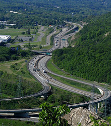
[2] After this, I-287 passes through rock cuts in the Ramapo Mountains before making a sharp turn east as it crosses high above the Wanaque River valley on a bridge.
[2] At this point, Route 17 forms a concurrency with I-287 and the road widens to six lanes as it passes between the Ramapo Valley County Reservation to the west and business parks to the east.
[4][5] At this point, NY 17 splits north onto I-87 and I-287 joins I-87 on the eight-lane New York State Thruway, passing over Metro-North Railroad's Port Jervis Line as it heads east out of the mountains into suburban residential and commercial surroundings as it narrows to six lanes.
[5] After briefly running along the south edge of the village of Spring Valley, where there is a westbound toll gantry for trucks, the highway fully enters Chestnut Ridge.
As the Thruway continues into West Nyack, it passes under CSX Transportation's River Subdivision line before coming to the exit for NY 303 that provides access to the Palisades Center shopping mall to the south of the road.
[3][4] From here, the New York State Thruway crosses the Hudson River on the Tappan Zee Bridge east into the village of Tarrytown in the town of Greenburgh in Westchester County.
[3][4] The I-287 freeway heads south along the White Plains–Harrison border before turning east and fully entering Harrison, where there is a cloverleaf interchange with the Hutchinson River Parkway.
[5] The Cross Westchester Expressway comes into the village of Port Chester, where the road runs near more dense suburban development as it intersects US 1.
[3] From here, the mainline I-287 narrows to four lanes and enters the city of Rye, where it passes over the Northeast Corridor before merging into northbound I-95 about a half-mile (0.80 km) west of the Connecticut state line.
[9] The southern segment of I-287 was planned in the 1950s as the Middlesex Freeway, which was to run from the Outerbridge Crossing to Staten Island and follow the Route 440 corridor to Edison, where it would connect to the New Jersey Turnpike before continuing west to I-78.
[7] That interchange was not complete until 1994, but the highway opened as planned on November 19 in a ceremony held on the Wanaque River bridge, where New Jersey Governor James Florio cut the ribbon.
[19][21] On July 16, 1999, Governor Christine Todd Whitman banned oversize trucks from using roads that are not part of the National Highway System, such as Route 31.
[24] Near the end of that year, five people and a dog were killed when a small SOCATA TBM 700 airplane en route to Georgia crashed on the highway near exit 33 in Morris Township.
[25] In August 2007, NJDOT started the I-287 (Middlesex Freeway) Rehabilitation Project to resurface the pavement between exit 5 in South Plainfield and I-95/New Jersey Turnpike in Edison Township, which is used by about 150,000 vehicles daily.
[31] The portion of the Thruway currently followed by I-287, including the Tappan Zee Bridge over the Hudson River, opened on December 15, 1955.
[37] The I-87/I-287 interchange split near Tarrytown began a $187-million (equivalent to $307 million in 2023[10]) reconstruction in 2001 in order to add additional lanes and rebuild overpasses and underpasses.
[41] Plans for a limited-access road to cross Westchester County east to west date back to the 1920s and became more needed after post-World War II traffic increases.
The plans for the bridge, and the I-287 extension onto Long Island, were dropped in 1973 by Governor Nelson Rockefeller as a result of community opposition and environmental concerns.
[46] On July 27, 1994, a propane truck crashed into an overpass on the Cross Westchester Expressway in White Plains and exploded, killing the driver.
[51] The Federal Highway Administration (FHWA) issued a report in October 2011 designating the Tappan Zee's replacement to be dual-span twin bridges.
[60] In 2008, a private firm, Polimeni Associates, proposed to construct a more than 16-mile-long (26 km) tunnel across Long Island Sound between Rye and Oyster Bay.