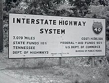
Interstate 40 in Tennessee
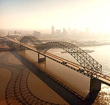
[11] The highway then intersects US 51 (Danny Thomas Boulevard) and, just beyond this point, abruptly turns 90 degrees north near Midtown at an interchange with the western terminus of I-240, a southern bypass route around the central city.
[12][13] A few miles later, I-40 reaches a complex four-level stack interchange with US 64/70/79 (Summer Avenue) and the eastern ends of I-240 and Sam Cooper Boulevard; a pair of overpasses carries its traffic northeast.
Entering a straightaway, the Interstate crosses the Wolf River for a third (and final) time; over the next several miles, it passes through the suburban neighborhoods of East Memphis and Cordova and the incorporated suburb of Bartlett in eastern Shelby County.
[12][13] Leaving the Memphis area, I-40 enters Fayette County east of Arlington; about five miles (8 km) later, it crosses the Loosahatchie River and adjacent wetlands.
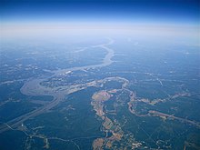
[11][21][22] Crossing the Tennessee River into Humphreys County, I-40 exits the refuge after a few miles and traverses vast woodlands in the rugged hills of the Western Highland Rim.
[27] I-40 then widens to eight lanes, and has a four-level interchange with SR 155 (Briley Parkway, White Bridge Road) which includes the western terminus of a northern controlled-access beltway around Nashville.
It then crosses Falling Water River and begins a steep, approximately five-mile (8.0 km) ascent onto the Cumberland Plateau, reaching an elevation of nearly 2,000 feet (610 m) at the top.
Next is an exit for SR 62 (Western Avenue), followed by a three-level interchange with the southern terminus of I-275; the eastbound lanes also have access to US 441 southbound (Henley Street).
The highway crosses a long viaduct over a rail yard before reaching an interchange with SR 158 (James White Parkway) westbound, a controlled-access spur which accesses downtown Knoxville and the University of Tennessee to the south.
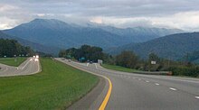
This interchange is the primary access to the Great Smoky Mountains National Park and tourist attractions in Sevierville, Pigeon Forge, and Gatlinburg, and is one of Tennessee's busiest non-Interstate exits.
[15][47] Beginning a moderate descent, the highway crosses the Douglas Lake reservoir of the French Broad River a few miles later and enters Cocke County after a gradual climb.
[49] After leaving Newport, the road crosses the Pigeon River, intersects SR 73 near Cosby, and again turns south for a view of 4,928-foot (1,502 m) Mount Cammerer at the northeastern end of the Great Smoky Mountains.
[58][59] In 1990, the segment from near Farragut to the North Carolina line was named "Troy A. McGill Memorial Highway" after a Knoxville-born U.S. Army soldier who posthumously received the Medal of Honor for his actions during the Admiralty Islands campaign in World War II.
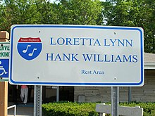
[62] A number of short sections, bridges, and interchanges are named for state troopers and TDOT employees killed in the line of duty, as well as local politicians and other prominent citizens.
[141] The section through the Pigeon River Gorge in Cocke County into North Carolina was initially believed by some engineers to be impossible to build and was among the nation's most difficult and laborious highway projects, requiring thousands of tons of earth and rock to be moved.
[148] Work on the final segment between Memphis and Knoxville, approximately 5.5 miles (8.9 km) from the interchange with I-65 to the western split with I-24 southeast of downtown Nashville (including the concurrency with I-65), began in May 1969 and opened on March 3, 1972.
[152][153] The nine-mile (14 km) segment from SR 299 to US 27 near Harriman and Rockwood, including the descent down Walden Ridge, was the last section of I-40 completed between Memphis and Knoxville, and was repeatedly delayed by geological problems.
[162] Due to its location within a floodplain, an artificial fill of 23 million cubic yards (18×10^6 m3) of sand and silt was required for the roadbed, most of which was dredged and pumped from the bottom of the Mississippi River via a pipeline.
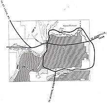
[171] The movement was also backed by environmentalists, who feared that the Interstate's construction would upset the park's ecological balance; the wooded area had become an important stopover for migratory birds.
[170][176] On January 9, 1981, Governor Alexander submitted a request to Secretary of Transportation Neil Goldschmidt to cancel the route through Overton Park, which was approved seven days later.
[177][178] On June 28, 1982, the American Association of State Highway and Transportation Officials approved an application by TDOT to redesignate the northern portion of I-240 as the remainder of I-40;[179] this added about 3.4 miles (5.5 km) to the route.
[186] The construction of I-40 through Jefferson Street resulted in many Black residents being displaced to the Bordeaux area of North Nashville, and led to the predicted economic downturn in the neighborhood.
[200] In November 1977, TDOT installed a system to detect tailgating vehicles in the westbound lanes of the concurrent segment with I-24: sensors embedded in the roadway which were connected to overhead warning signs with flashing lights and horns.
[207] West of downtown Nashville, the three-mile (4.8 km) section between SR 155 (Briley Parkway/White Bridge Road) and US 70 (Charlotte Pike) was expanded to six lanes from February 1988 to December 1989.
[242] In 1989, TDOT began preliminary planning work to widen the four-lane section from east of I-275 to Broadway/Hall of Fame Drive, and reconstruct the accident-prone interchange with SR 158 (James White Parkway), which contained left-hand entrance and exit ramps.
[264] In response to the incident, between January 1987 and December 1988, workers flattened the cut slopes along this stretch of the Interstate and moved a 1,000-foot (300 m) section of the road 60 feet (18 m) from the problematic cliffside.
In the late 1970s and early 1980s, workers dug over 24,000 feet (7,300 m) of horizontal drains, blasted out a large number of unstable rocks, and installed mesh catchment fences.
[272] Torrential flooding in the Pigeon River from the aftermath of Hurricane Helene washed away a small section of the eastbound shoulder and embankment near the state line on September 27, 2024, closing the roadway to all traffic.
[36] On December 23, 1988, a tanker truck hauling liquified propane overturned on a one-lane ramp carrying I-40 traffic through the Midtown interchange with I-240 in Memphis, poking a small hole in the front of the tank.
[274][275] The leaking gas ignited in a boiling liquid expanding vapor explosion (BLEVE), producing a fireball that set nearby vehicles and structures on fire and instantly killed five motorists (including the truck driver).