Interstate 684
The highway connects I-84 with I-287 and the Hutchinson River Parkway, primarily serving commuter traffic to and from the northern suburbs of the New York metropolitan area.
From the junction of the two spurs, the Interstate Highway takes a straight course to the north-northwest through a wooded corridor with Century Country Club on the west and residences on the east.
Signage indicates this, but it retains its New York reference markers as it curves more to the northeast for the next 1.41 miles (2.27 km) through wooded and swampy country in the western corner of Greenwich.
A mile (1.6 km) after it reenters New York, in the town of North Castle, it reaches its next exit, where NY 22 serves that community and the nearby hamlet of Armonk.
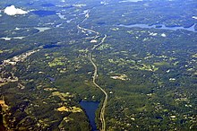
At Byram Lake Reservoir, it returns to a northward heading for a mile (1.6 km), crossing into the town of Bedford.
Over the next two miles (3.2 km), the Interstate curves gently back and forth, maintaining its generally northerly heading, as its median strip widens slightly.
The Saw Mill merges from the southeast, its two roadways forming service roads flanking I-684 for the next mile (1.6 km) as it passes a southern extension of Muscoot Reservoir just east of the hamlet of Katonah.
A half-mile (800 m) north of the merger, the frontage roads merge into the Interstate at the exit for NY 35, serving Katonah and the hamlet of Cross River to the east.
A northbound-only exit leads onto it, allowing access to NY 138, which crosses the Interstate at the hamlet of Goldens Bridge.
When it returns, the roads and the railroad tracks bend strongly to the northeast, following the Croton River on their west.
The Hardscrabble Road exit serves both directions and, via NY 22, allows access to the nearby hamlet of Croton Falls.
An almost-complete cloverleaf interchange guides traffic east to Danbury, Connecticut, or west toward Newburgh.
In 1961, the proposed routing of I-87 north of Elmsford along the east bank of the Hudson River was relocated to use the NY 22 corridor instead via modern I-287 and I-84.