New York State Route 22
In the early 20th century, as automobile use became widespread, the state paved the more heavily used sections and built new roads to create the current highway, first designated as NY 22 in 1930.
After running northerly from its origin in the Bronx it veers slightly to the northeast in the vicinity of a traffic circle near Kensico Dam before heading northward for good as a mostly two-lane rural route all the way to the state's North Country.
Of the surface road intersections, 18 terminate at NY 22 and 15 are concurrencies shared with the crossing routes, accounting for 72.6 miles (116.8 km), or 21.5% of the highway's total length.
[10] NY 22 starts as Provost Avenue at U.S. Route 1 (US 1) in the Eastchester section of the Bronx, intersecting with East 233rd Street about 0.2 miles (320 m) to the north.
[5] Shortly after the county line, NY 22 makes a sharp turn to the east at the South Columbus Avenue intersection, soon passing St. Paul's Church National Historic Site on its north, then curving back to that direction.
[5] In North White Plains, the surrounding area becomes less developed as NY 22 becomes a four-lane undivided expressway, and goes over a gentle rise from which a short connector runs downhill to the traffic circle where the BRP ends and the Taconic State Parkway begins, just south of Kensico Dam.
[5] The combined roads pass just west of IBM's Armonk headquarters and the "Duke's Trees angle", the westernmost point in Connecticut, after which NY 22 becomes a four-lane divided expressway.
[5] After that junction, NY 22 bends back to the north, paralleling I-684 through the Westchester countryside of large wooded lots and houses well-screened from the road.
In downtown Bedford, the first settlement since White Plains, the highway overlaps with NY 172 for a mile (1.6 km), its first concurrency with an east–west route, then veers back to the northwest at the center of town.
At another traffic light 400 feet (120 m) to the north, NY 116 goes east to Titicus Reservoir at the northern intersection, the highway crosses under I-684, remaining between it and the railroad tracks.
[e] Immediately afterward, the road crosses back under the railroad again and enters Putnam County, following the Croton River north past the spillway of East Branch Reservoir.
[5] After paralleling the reservoir for almost two miles (3.2 km), a third route, US 6, joins the concurrency just east of the village of Brewster, forming the only three-route overlap along NY 22.
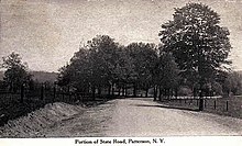
It then resumes its northward heading, following a much straighter course than it had up to this point, on two lanes through wooded areas of the town of Patterson, where two local state highways, NY 312 and 164, come in from the west.
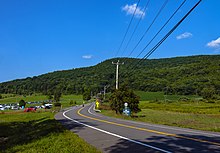
Past the village, the railroad tracks edge closer to the highway as NY 22 enters the scenic Harlem Valley, near the lower end of the Taconic Mountains.
US 44 continues eastward towards Lakeville, Connecticut, only a mile (1.6 km) east at this point, while NY 22 resumes its northward course into the shadow of the ridge ahead, where 2,311-foot (704 m) Brace Mountain, Dutchess County's highest peak,[15] dominates the view.
[5] NY 22 then veers sharply to the northeast, resuming a northward direction within 150 feet (46 m) of the state line, the highway's closest approach to it along its entire length.
After turning northeast to join it at a traffic light, NY 22 overlaps with Route 7 for 1,500 feet (460 m), then forks off to the north just before crossing the Hoosic River.
There are no other state routes here, but after another two miles (3.2 km), at North Hoosick, NY 67 comes in from the east and the two roads overlap as they leave Rensselaer County.
[5] North of Cambridge, the highway continues through a rolling landscape of fields and farms, the low transitional country between the Appalachians and the Adirondacks.
It heads northwest a little further until, after passing between Great Meadows and Washington state prisons, it reaches US 4 and turns right to join it, resuming its northward course.
[5] As NY 22 bends westward after leaving Whitehall, it rounds the north end of the ridge to the west, offering views into Vermont.
The stream at the bottom of this valley, surrounded by the low lying Drowned Lands flood plain, is the inflow for Lake Champlain.
NY 22 has now entered the Adirondack Park, the 6.1-million-acre (25,000 km2) Forest Preserve and National Historic Landmark, and the largest publicly protected area in the contiguous United States.
The road remains close to the widening lake for the next 15 miles (24 km), with the tracks of the Delaware and Hudson Railroad, used today by CSX for freight and Amtrak for passenger service between New York and Montreal, sometimes immediately to the east.
NY 22 and US 9 join, closely parallel to the Adirondack Northway (I-87), the only other route in the state to directly connect New York City with Canada.
NY 22 enters Clinton County just north of Keeseville, and then leaves Adirondack Park two miles (3.2 km) beyond at the Peru town line.
[26] The road from the modern-day Bronx (then part of Westchester County) through White Plains to Bedford and points north was originally an old Native American path.
[27] Further north, near Lake Champlain, the route now used by NY 22 was used by the St. Francis Indians of Canada as they went south to find warmer fishing areas.
[39] In the original plan for the U.S. Highway System, as approved by the Bureau of Public Roads in November 1926,[40] US 7 was defined as beginning in New York City and designated on the alignment of NY 22 to Amenia, where it shifted northeast into Sharon, Connecticut, to use old New England Route 4 through Massachusetts and Vermont all the way to the Canadian border.
[43][49] Within the 44/22 concurrency, part of CR 5 (and its short spur 5S), a mile-long (1.6 km) loop west of the highway south of Millerton, is also a former alignment of NY 22.