Interstate 90 in Washington
A compromise agreement was reached by the federal, state, and local governments in 1976 to build a second floating bridge across Lake Washington and include extensive parks above tunneled sections of I-90, which were completed in the early 1990s.
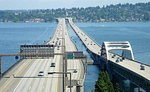
The old bridge's center pontoons sank during a November 1990 windstorm due to a contractor error and were rebuilt over the following three years, reopening to traffic on September 12, 1993, marking the completion of the transcontinental highway.
The interchange is adjacent to T-Mobile Park, home to the Seattle Mariners baseball team, and includes a pair of ramps to SR 519 and an additional offramp to 4th Avenue South north of Royal Brougham Way and near Lumen Field.
[17] The freeway wraps around the north end of Beacon Hill and intersects Rainier Avenue at the site of the future Judkins Park light rail station, joined by a multi-use bicycle and pedestrian trail that forms part of the Mountains to Sound Greenway.
I-90 travels to the south of Enatai and Beaux Arts Village and intersects Bellevue Way, where light rail tracks turn north away from the freeway, before crossing the Mercer Slough and its wetlands.
At the east end of the arc near the Asahel Curtis Picnic Area, the freeway's westbound and eastbound lanes are split by a wide median that includes the Denny Creek Campground.
[40][41] I-90 has several chain-on and chain-off areas on the highway shoulders between North Bend and Cle Elum, including variable-message signage to inform drivers of road conditions.
[42][43] WSDOT estimates that it costs $2–3 million annually to keep Snoqualmie Pass open in the wintertime, which sees an average snowfall of 233 inches (590 cm) and about 120 hours of closures per year.
The freeway then passes several scenic viewpoints for Lake Wanapum and the Wild Horse Monument,[17] a piece of public art placed atop a hill to the east.
[3] The freeway continues due east across rural Grant County, paralleled by a pair of frontage roads, past several sand dunes, state recreational areas, and the Potholes Reservoir.
The freeway then crosses the Pelican Horn and intersects SR 17 before leaving the city, regaining its frontage roads as it continues east across rural Adams County by following several coulees.
The two highways intersect SR 261 and travel northeast along the BNSF railroad, which carries Amtrak's Empire Builder trains, to Sprague Lake in Lincoln County.
[53][55][56] The wagon road was popular with settlers and cattle drivers from eastern Washington and was planned to be extended west to the Black River and east to the Yakima Valley using a $2,500 appropriation from the territorial government, but the funds proved insufficient and the project was shelved.
[66] The state legislature passed an appropriations bill in March 1913 that funded construction of the trunk routes, including a total of $506,834 for the cross-state road, dubbed the "Sunset Highway".
[70] The road across Snoqualmie Pass was mostly complete by September 1914, leading to plans for a formal dedication, but heavy rainfall delayed earthwork along the highway and postponed its use by motorists.
[72] It reopened to traffic on June 20, 1915,[73] and the highway was formally dedicated at the summit of Snoqualmie Pass on July 1, 1915, by a party of 400 motorists led by Governor Ernest Lister and Seattle Mayor Hiram Gill.
[79][80] Portions of the Sunset Highway remained graded but unpaved until funds from the Federal Aid Road Act of 1916 were used to pave a gravel surface; some sections in King County were also upgraded with concrete pavement.
[103][104] The federal government endorsed proposals for a transcontinental system of "superhighways" that were transmitted by the Roosevelt administration and the Bureau of Public Roads (BPR) to Congress in the late 1930s.
[127] Planning for the east–west freeway through Downtown Spokane began in the mid-1940s, with city leaders undecided on a specific route but generally favoring a corridor on the south side of the central business district.
[133][134] Officials from Deaconess Hospital lobbied the state government for a freeway noise study that would determine the effects of various routing options and asked the city council to delay its approval.
[138][139] The state highway commissioned announced in September 1960 that it would continue to pursue the 3rd–4th alignment that had been originally chosen, with enhancements to prevent unnecessary noise next to the hospital, at the recommendation of the Bureau of Public Roads.
[140] Construction of the Spokane Freeway began in 1961 with a section over Sunset Hill and the Hangman Creek bridges, which were completed in June 1963 at a cost of $2.2 million but remained closed to traffic.
[148] The freeway was extended 16.7 miles (26.9 km) southwest from Four Lakes to Tyler on November 18, 1966, following a dedication by Governor Daniel J. Evans, whose plane landed on the unopened lanes.
It cost $17.7 million to construct and included 31 bridges, three crossings of the Yakima River, a high fence for elk, and several gravel pits that were converted into fishing ponds.
[165][166] Later that year, the state highway commission unsuccessfully proposed a 92-mile (148 km) westward extension of I-90 from Seattle to Bremerton via a bridge over Puget Sound and continuing on to Aberdeen on the Pacific Ocean.
[167] Expansion of the last two-lane section of I-90 in Eastern Washington, spanning 26 miles (42 km) from Schrag to Ritzville, began in August 1971 and was completed two years later at a cost of $16 million.
[177] The final section's construction was described by local politicians as "the end of an era" and a "dinosaur" due to its conflicts with Seattle's long-term plans for transit and reducing driving.
[186] Before 2003, Interstate 90 used to end at a signalled intersection with 4th Avenue S. However, increasing traffic from Downtown Seattle, Colman Dock, T-Mobile Park, and CenturyLink Field forced city, county, and state officials to look for improvements to the area.
The first stage of the improvements, the SR 519 South Seattle Intermodal Access Project, included the construction of a new on-ramp to Interstate 90 via a new interchange with 4th Avenue S. and Edgar Martínez Drive S. (formerly S. Atlantic Street).
[201][202] The west end of the network was at the intersection of 5th Avenue, Airport Way, and Dearborn Street in the International District, adjacent to the Union Station complex and Lumen Field.