Interstate 5
It travels through the states of California, Oregon, and Washington, serving several large cities on the West Coast, including San Diego, Los Angeles, Sacramento, Portland, and Seattle.
I-5 is a major Interstate Highway that spans 1,381 miles (2,223 km) and runs north–south through the West Coast states of California, Oregon, and Washington.
At Dana Point, I-5 turns inland and heads north through Mission Viejo to the El Toro Y interchange in Irvine, where I-405 splits and carries the San Diego Freeway designation.
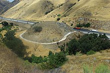
The freeway passes the city of Santa Clarita and ascends into the Sierra Pelona Mountains, where the northbound and southbound lanes separate and cross sides for approximately 5 miles (8.0 km).
Now named the West Side Freeway,[4] I-5 travels northwest along the edge of the Central Valley through farmland and avoids populated areas.
After an unsigned concurrency with State Route 99 in northern Sacramento, the freeway turns west to pass the city's airport and resumes its northwestern path at Woodland.
I-5 then travels due north through farmland on the east side of the Willamette River, passing a junction with US 20 in Albany, and bisects eastern Salem near the state capitol campus.
[5][15] From Salem, I-5 turns northeast and passes Woodburn before crossing the Willamette River on the Boone Bridge in Wilsonville, at the south end of the Portland metropolitan area.
The freeway travels through the southern suburbs of Portland, intersecting I-205 in Tualatin and Oregon Route 217 in Tigard before entering the city proper.
The freeway continues north through the South Waterfront neighborhood, crossing under the Portland Aerial Tram and the western approach to the Ross Island Bridge (carrying US 26) before reaching an interchange with I-405.
[5][14] I-5 and I-405 form a complete loop around downtown Portland, with I-5 crossing the Willamette River on the Marquam Bridge to run along the eastern riverfront.
The freeway turns north again after leaving Tacoma and its nearby seaport near Fife to traverse the suburbs of South King County.
[17] The freeway generally follows the Green and Duwamish rivers into Seattle, passing Boeing Field and the industrial district in the process.
[17] The section between downtown Seattle and Northgate includes a set of reversible express lanes that add extra capacity in the peak direction of travel.
The freeway travels north through Everett, skirting the city's downtown and intersecting US 2, and leaves the Seattle metropolitan area for the rural Skagit Valley.
I-5 descends into the valley and travels through Mount Vernon and Burlington before climbing into the Chuckanut Mountains, where it turns west towards Bellingham Bay (part of the Salish Sea).
[17] An extensive section of this highway (over 600 mi (970 km)), from approximately Stockton, California, to Portland, Oregon, follows the track of the Siskiyou Trail.
[20] This trail was based on an older network of Native American footpaths connecting the Pacific Northwest with California's Central Valley.
To provide a faster and more direct north–south route through the state, the decision was made to build a new freeway to the west and bypass Fresno, Bakersfield, and the rest of population centers in the area instead of upgrading the existing highway (which was re-designated as part of SR 99).
[2] On May 23, 2013, a bridge span collapsed over the Skagit River in Mount Vernon, Washington, sending two cars into the water and requiring traffic in both directions to bypass the crossing.
[26] The Washington State Department of Transportation used a temporary structure to restore access across the river while a permanent bridge replacement was built.
[29] In 2019, the three states also broke ground on a similar charging network for electric trucks along I-5 called the West Coast Clean Transit Corridor Initiative.