Interstate 5 in Oregon
[4] The highway connects several of the state's largest metropolitan areas, which lie in the Rogue and Willamette valleys,[5] and passes through counties with approximately 81 percent of Oregon's population.
[19] At the west end of the valley in Josephine County, the freeway reaches Grants Pass and intersects U.S. Route 199 (US 199), which connects to Crescent City, California, on the Pacific Coast.
[19] The freeway crosses into Douglas County near Stage Road Pass east of Glendale and turns northeast to follow the Cow Creek valley before resuming its northern course through the mountains.
[5][15] Within Roseburg, the freeway runs along the west bank of the South Umpqua River opposite from the city's downtown and passes through several residential neighborhoods near the regional airport.
At Harvard Avenue, I-5 begins a concurrency with OR 138 that continues for 12 miles (19 km) to Sutherlin, running parallel to OR 99 as the highways cross the North Umpqua River.
Between the Willamette Town Center shopping mall and the Oregon State Fairgrounds, the freeway intersects the south end of OR 213, a local highway that parallels I-5 to the east towards the Portland area.
The freeway continues northwest into Keizer and intersects Salem Parkway, a divided highway carrying OR 99E Business, at an interchange that straddles the 45th parallel (marked with a sign in the median).
[5][19] It reaches a junction with OR 551 north of Aurora State Airport and adjacent to the French Prairie rest area, which includes a seven-acre (2.8 ha) solar power array with 7,000 panels.
[15] In the South Burlingame neighborhood, the freeway begins a fishhook-shaped turn through the "Terwilliger curves", a notoriously dangerous section of I-5 that changes directions five times in one mile (1.6 km).
[27] I-5 continues north from the Terwilliger curves through South Portland, running uphill from OR 43 on the western bank of the Willamette River and downhill from Barbur Boulevard (now carrying OR 10 and OR 99W).
The freeway dives northeasterly towards the South Waterfront district to avoid Marquam Hill, home of the Oregon Health & Science University campus.
The lanes of OR 43 are split between Hood and Macadam avenues on west and east sides of I-5 as it crosses under the Portland Aerial Tram and Gibbs Street Pedestrian Bridge.
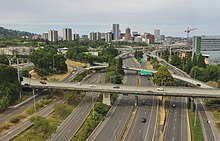
[28] The freeway passes under the Ross Island Bridge (part of US 26) and reaches the southern terminus of I-405, which it intersects in a large Y interchange situated over the light rail tracks of the MAX Orange Line and the Portland Streetcar.
The east end of the bridge, adjacent to the Oregon Museum of Science and Industry, has a southbound stub ramp that was built to serve the cancelled Mount Hood Freeway.
[29] Between the Boise and Eliot neighborhoods, the freeway intersects the terminating I-405 a short distance from the Fremont Bridge, which carries US 30 west into the Pearl District after it splits from I-5.
[15] The interchange, located between the Legacy Emanuel Medical Center and Albina railyard,[34] has a set of three stub ramps that were built for the cancelled Rose City Freeway and were re-purposed to serve the hospital.
[36] I-5 continues north and passes Peninsula Park and the Cascade campus of the Portland Community College in the Piedmont neighborhood before reaching an interchange with Lombard Street, which carries the US 30 Bypass.
From the Lombard Street interchange, the freeway turns northwest and crosses over the Columbia Slough, reaching Delta Park on the site of the former city of Vanport.
[46] The Oregon state legislature authorized the construction of controlled-access "throughways" (now called freeways) in 1947 and the Pacific Highway was designated as a future corridor the following year.
[54] Although not generally referred as such, the portion of I-5 south of Portland near Tigard to Salem was formerly named the Robert Hugh Baldock Freeway after a former Oregon highway engineer.
[46][60] The first section of the East Bank Freeway in Portland, running 2.5 miles (4.0 km) from the Morrison Bridge to Shaver and Failing streets, opened to traffic on January 7, 1964.
Its design was criticized by the public and the Portland Art Commission, who described it as "so gross, so lacking in grace, so utterly inconsistent with any concept of aesthetics" in a formal complaint.
[46] Beginning in 1976, the State Highway Division (now ODOT) experimented with asphalt recycling from construction projects on the I-5 corridor to repave local roads.
[67] The gravel ramp is controlled by a locked gate and was approved for construction following the 2020 Almeda fire, which started in the area and destroyed 2,500 homes.
[69][70] The program was cancelled in 2013 due to opposition within the Washington state legislature; $200 million had been spent during planning, which included federal funds that would need to be reimbursed unless a new proposal was submitted.
[71] The updated design would include an eight-lane toll bridge, a multi-use trail for cyclists and pedestrians, and a MAX Light Rail extension into Vancouver.
[74] The agency's proposal—the addition of an auxiliary lane for merging and weaving traffic, as well as a freeway lid—would cost $450 million and was approved by the state legislature that year.
[76][77] In June 2020, several elected officials from the city and county governments announced that they would not support the proposal, following a local nonprofit advocacy group from the Albina neighborhood that did the same.
[78] A new design with larger freeway lids and potential for development, estimated to cost $1.25 billion, was adopted by ODOT in September 2021; the city government later returned to the project, which was expected to begin construction in 2025.