Iskar (river)
[2] Originating as three forks in Balkan's highest mountain range Rila, the Iskar flows in a northern direction until its confluence with the Danube.
As it flows northwards it fuels the largest artificial lake in the country, the Iskar Reservoir, forms the divide between the Vitosha and Plana Mountains in the west and the Sredna Gora mountain range in the east before entering the Sofia Valley, which contains the nation's capital Sofia.
North of the Balkan Mountains, the river crosses the Danubian Plain and finally flows into the Danube between the villages of Baykal and Gigen.
The Iskar has a significant economic importance, providing water for the needs of the capital and a number of manufacturing plants.
It waters are also utilised for irrigation and electrical energy generation, while the scenic gorges and rock formations throughout its course provide excellent conditions for recreation.
[11] The Iskar headwaters consist of three forks in the northern slopes of Rila, Bulgaria's highest mountain range.
[12] Beli (white) Iskar is the longest of the three with a length of 28 km and its springs are at the northern slopes of the Redzhepitsa Peak (2,677 m).
[15] It flows through a deep valley for 18 km until its confluence with Cherni Iskar downstream of the village Mala Tsarkva and has a watershed of 56 km2.
[15] Iskar proper is formed by the confluence of Beli and Cherni Iskar and remains a typical mountain turbulent river with very large inclination and dragging force before entering the Samokov valley at an altitude of 950 m.[13] It flows through the town of Samokov and is joined by its first significant left tributary, the Palakaria a few kilometres to the north.
[13] As it enters the Sofia Valley (550 m) at the aforementioned village it turns northwards and forms a wide river bed.
[13] The river enters the Balkan Mountains at the town of Novi Iskar and forms a long and spectacular gorge, whose slopes reach a height of 200 m up to 500 m at some points.
Up to Gara Bov the Iskar flows through very eroded rocks and the gorge is wide with better developed and preserved river terraces.
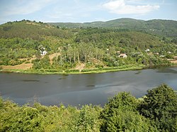
[13] At Lyutibrod the Iskar enters the Pre-Balkan hills where it forms its fourth gorge with a length of 64 km.
[13][17] In the past, the riverbed was carved into an alluvial bottom and due to the small inclination the river used to form meanders with swampy banks.
The European Union network of nature protection areas Natura 2000 includes several protected areas along the river, such as the section of the Pancharevo Gorge under the code Plana BG0001307[21] and the lower course of the Iskar in the vicinity of the town of Dolni Dabnik under the code Iskar River BG0000613.
[24] The only freshwater fish of the order Gadiformes, the burbot, inhabits the lower course near the Danube, which is among the southernmost points of its range.