List of islands of Tuvalu
The soils of Tuvalu's islands are usually shallow, porous, alkaline, coarse-textured, with carbonate mineralogy and high pH values of up to 8.2 to 8.9.
The sea level at the Funafuti tide gauge has been rising at a rate of 3.9 mm per year, and it has been determined that rising sea levels are causing more wave energy to be transferred across reef surfaces, which has tended to push more sand onto island shorelines, increasing islands’ land area.
The islands of Tuvalu are spread out between the latitude of 5° to 10° south and longitude of 176° to 180°, west of the International Date Line.
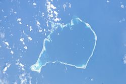
[6] The reef platforms do have a completely enclosed rim of dry land, and the rim surrounds the remnants of a lagoon, but these lagoon remnants have no connection to the open sea, and tend to dry up as coral debris accumulates in them over time.
An expedition (Funafuti Coral Reef Boring Expedition of the Royal Society) under Professor William Sollas of Oxford University, conducted by the Royal Society of London carried out drilling on the coral reef at Funafuti in 1896, 1897 and 1898.
[9] HMS Penguin, under the command of Captain Arthur Mostyn Field, delivered the 1896 expedition to Funafuti in the Ellice Islands, arriving on 21 May 1896, and returned to Sydney on 22 August 1896.
[7] From 1896 to 1899 the Penguin was under the command of Captain Arthur Mostyn Field and her surveying work included further voyages to Funafuti atoll to deliver the expeditions of the Royal Society in 1897 and 1898.
This investigation followed the work on the structure and distribution of coral reefs conducted by Charles Darwin in the Pacific.
From this point it rises vertically, like an enormous pillar, till reaches the surface in the form of a reef enclosing a lagoon of irregular size, but of which the extremities give a measurement of 13.5 by 10.0 miles”.