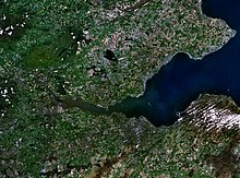
Islands of the Forth
Most of the group lie in the open waters of the firth, between the Lothians and Fife, with the majority to the east of the city of Edinburgh.
The scientific name for the northern gannet was chosen in recognition of this bird's connection with the Bass Rock.
Only one of these islands, Inchcolm, has had a resident population in recent years, although there have been monasteries, hermitages, lighthouses and fortifications on most of them in the past.
The Isle of May's rock is "fine grained basalt of a dark-grey colour with tinges of green and greenstone".
Studies of the landscape beneath the waters of the firth have revealed that the visible surface of Inchgarvie is only the top of a larger crag and tail structure similar in structure to Edinburgh Castle and the Royal Mile created by glacial action.
[12] Most of Inchkeith is of volcanic origin but there are also sections of sandstone, coal, limestone and shale, the last named containing numerous fossils.
[14] The Firth is an important area for nature conservation and has a range of habitats including extensive mudflats, shingle shorelines and saltmarsh.
[17] When viewed from the mainland much of the rock looks white due to the sheer number of birds (and their droppings, which give off 152 tonnes of ammonia per year).
The bird was traditionally known locally as the solan goose, and its eggs and meat were considered delicacies.
Other bird species on the rock include guillemot, razorbill, cormorant, puffin, eider duck and numerous gulls.
[19] Craigleith lies close to North Berwick's harbour and historically was used as a rabbit warren.
A five-year project, SOS Puffin, led by the Scottish Seabird Centre at North Berwick, was launched early in 2007.
Since then, hundreds of volunteers have been working hard to rid the island of the problem, ferried out by boat from the Seabird Centre during the winter months, when the puffins are at sea.
They have also been affected by the successive influences of Celtic, Norse and English-speaking peoples during the historic period and this is reflected in their names.
(More plague sufferers came from the mainland in 1609 and in 1799, Russian sailors who died of an infectious disease were buried there.
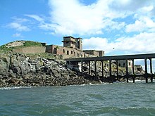
His force of marines were ordered to reinforce Inchkeith, and they built a large square fort, with corner towers, on the site of the present day lighthouse.
He was buried in a stone coffin on the island but is said to have floated across the Firth before coming to rest in a churchyard at Anstruther.
[31][32] Inchcolm has connections to St Columba and King Alexander I was marooned on the island, and decided to make it the site of an Augustinian monastery.
There are various lighthouses[33] and numerous devices to guide shipping in the busy waters near the ports of Leith and Rosyth.
In 1803, construction was begun of Inchkeith Lighthouse, designed and built by Thomas Smith and Robert Stevenson.
At that time it was controlled by a clockwork timer and was powered using gas delivered weekly from Granton gasworks.
[5] The Isle of May light has a long history having been in operation since 1635 when a crude coal-fired structure was erected.
Rocks known as the Cow and Calf lie to the north and beyond that, about halfway to Inchcolm, are the Oxcars, a hazard identified by a permanent light.
[51] There is a resident custodian employed by Historic Scotland who maintains the island and runs the shop during the summer.
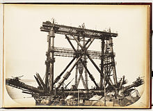
When construction of the bridge recommenced in 1882, the west end of the island was extended with a pier and used as the foundation for one of the cantilevers.
[55][56] Just upstream is the smaller Tullibody Inch – both are part of the Firth of Forth SSSI, which also includes the John Muir Country Park.
More land was then reclaimed using ash slurry from Longannet power station from 1970 onward and it is now part of the mainland.
[11][57] Just offshore are the Craigmore Rocks at grid reference NT001845, which were called "Kraig Maur" in Blaeu's Atlas.
"Dow Kraig" on the same 17th century map appears to be under reclaimed land just along the coast south of Dunsyre House at grid reference NT116817[58][59] Nearby Rosyth Castle is a former tidal island[60] and Long Craig is now part of the Forth Road Bridge.