Isle of Arran
In the troubled Viking Age, Arran became the property of the Norwegian crown, until formally absorbed by the kingdom of Scotland in the 13th century.
The Island includes miles of coastal pathways, numerous hills and mountains, forested areas, rivers, small lochs and beaches.
Mac an Tàilleir (2003) says the name "is said to be unrelated" to those of Arranmore or the Aran Islands in Ireland, which come from Irish Árainn meaning "kidney-shaped", though he does not rule out this derivation.
[10] Unusually for a Scottish island, Haswell-Smith (2004) and William Cook Mackenzie (1931) offer a Brythonic derivation and a meaning of "high place" (c.f.
Middle Welsh aran) which at least corresponds with the geography – Arran is significantly loftier than all the land that immediately surrounds it along the shores of the Firth of Clyde.
[8][11] Any other Brythonic place-names that may have existed, save perhaps for Mayish,[12] were later replaced on Arran as the Goidelic-speaking Gaels spread from Ireland, via their adjacent kingdom of Dál Riata.
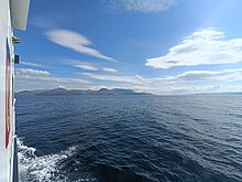
The profile of the north Arran hills as seen from the Ayrshire coast is referred to as the "Sleeping Warrior", due to its resemblance to a resting human figure.
[21] Arran is a popular destination for geologists, who come to see intrusive igneous landforms such as sills and dykes, and sedimentary and meta-sedimentary rocks ranging in age from Precambrian to Mesozoic.
Most of the interior of the northern half of the island is taken up by a large granite batholith that was created by substantial magmatic activity around 58 million years ago in the Paleogene period.
Within the central complex are subsided blocks of Triassic sandstone and marl, Jurassic shale, and even a rare example of Cretaceous chalk.
The mine was closed by the 11th Duke of Hamilton on the grounds that it "spoiled the solemn grandeur of the scene" but was reopened after the First World War and operated until 1938 when the vein ran out.
[26] Visiting in 1787, the geologist James Hutton found his first example of an unconformity to the north of Newton Point near Lochranza, which provided evidence for his Plutonist theories of uniformitarianism and about the age of the Earth.
[21] After the last retreat of the ice at the close of the Pleistocene epoch sea levels were up to 70 metres (230 ft) lower than at present and it is likely that circa 14,000 BP the island was connected to mainland Scotland.
[29] Sea level changes and the isostatic rise of land makes charting post-glacial coastlines a complex task, but it is evident that the island is ringed by post glacial raised beaches.
[37] The southern half of the island, being less mountainous, has a more favourable climate than the north, and the east coast is more sheltered from the prevailing winds than the west and south.
There are two good examples in Monamore Glen west of the village of Lamlash,[38] and similar structures called the Giants' Graves above Whiting Bay.
[41] Torr a' Chaisteal Dun in the south west near Sliddery is the ruin of an Iron Age fortified structure dating from about AD 200.
Arran of the many stags The sea strikes against her shoulders, Companies of men can feed there, Blue spears are reddened among her boulders.
[Note 1] Following Haakon's death later that year Norway ceded the islands of western Scotland to the Scottish crown in 1266 by the Treaty of Perth.
[52] Bruce returned to the island in 1326, having earlier granted lands to Fergus MacLouis for assistance rendered during his time of concealment there.
The local economy for much of this period was based on the run rig system, the basic crops being oats, barley and potatoes.
In the early 19th century Alexander, 10th Duke of Hamilton (1767–1852) embarked on a programme of clearances that had a devastating effect on the island's population.
[57][58] Goatfell was the scene of the death of English tourist Edwin Rose who was allegedly murdered by John Watson Laurie in 1889 on the mountain.
[72] At one point the coast road ventures inland to climb the 200 metres (660 ft) pass at the Boguillie between Creag Ghlas Laggan and Caisteal Abhail, located between Sannox and Lochranza.
The single-track road "The Ross" runs 15 kilometres (9 mi) from Lamlash to Lagg and Sliddery via Glen Scorodale (Gaelic: Gleann Sgoradail).
[76] Popular walking routes include climbing to the summit of Goat Fell, and the Arran Coastal Way, a 107 km (66 mi) trail that goes around the coastline the island.
Plans for 2008 for a large salmon farm holding 800,000 or more fish in Lamlash Bay have been criticised by the Community of Arran Seabed Trust.
[92] Arran landscapes have been the inspiration for numerous famous artists including Cragie Aitchison, Joan Eardley, Jessie M King, and Samuel Peploe.
Arran features in The Scottish Chiefs by Jane Porter[96] and Michael Peinkofer's children book series "Gryphony" is set on the island.
Over 250[103] species of bird have been recorded on Arran, including black guillemot, eider, peregrine falcon, golden eagle, short-eared owl, red-breasted merganser and black-throated diver.