Isthmus of Tehuantepec
The name is taken from the town of Santo Domingo Tehuantepec in the state of Oaxaca; this was derived from the Nahuatl term Tēcuāntepēc ("jaguar mountain").
The northern side of the isthmus is swampy and densely covered with jungle, which has been a greater obstacle to railway construction than the grades in crossing the sierra.
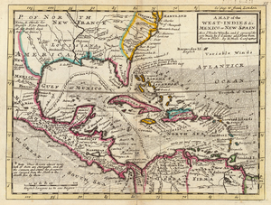
The Isthmus of Tehuantepec, a region located in the south of Mexico, is the narrowest area between the Atlantic and Pacific oceans in the whole country.
During the first half of the 16th century, it seemed as if nature could not withstand the strenuous effort of the Spanish conquistadores to find, within the tropics, a strait connecting the two oceans.
[5] Hernán Cortés, in 1520, used this route to transport equipment and supplies across the isthmus from the Gulf of Mexico to his shipyard located on the Pacific coast, near the town of Santo Domingo de Tehuantepec.
During the last third of the 16th century, Spanish expeditions arrived at the port of Veracruz, in the Gulf of Mexico, and from there they moved by boat to the mouth of the Coatzacoalcos River.
[11] As a result, the Isthmus presents a case of allopatric speciation wherein a geographic divide gives rise to population divergence and a significant decrease in gene flow.
[1] The narrowness of the isthmus, and the gap in the Sierra Madre, allow the trade winds from the Gulf of Mexico to blow through to the Pacific.
Common items include tamales made with iguana, chicken, beef or armadillo; guetabingui (fried balls of rice and shrimp); garnachas topped with dried queso Oaxaca; and pozol, a maize-based drink.
The 1854 Gadsden Purchase treaty[18] included a provision allowing the U.S. to transport mail and trade goods across the Isthmus of Tehuantepec via a plank road and railroad.
While the idea of a canal across the isthmus failed to gain momentum due to the enormous cost of such a project, engineer James B. Eads proposed to construct a quadruple track ship-railway, and the scheme received serious attention for some time.
An extensive system of quays and railway tracks at both terminals affords ample facilities for the expeditious handling of heavy cargoes.
The general offices and repair shops of the original Tehuantepec Railway were located at Rincón Antonio, at the entrance to the Chivela Pass.