Iztacalco
The area's history began in 1309 when the island of Iztacalco, in what was Lake Texcoco, was settled in 1309 by the Mexica who would later found Tenochtitlan, according to the Codex Xolotl.
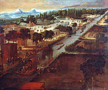
The island community would remain small and isolated through the colonial period, but drainage projects in the Valley of Mexico dried up the lake around it.
The area was transformed into a maze of small communities, artificial islands called chinampas and solid farmland divided by canals up until the first half of the 20th century.
[6][3] The Autodromo Hermanos Rodríguez, with adjoining Foro Sol is located on Avenida Viaducto Piedad in Colonia Magdalena Mixhuca.
[6][3] The La Viga Lienzo Charro (rodeo ring) is located on Guadalupe Street in Colonia Pantitlán.
[6] The main annual festival in the borough is the anniversary of the parish of San Matias in August, celebrating its establishment as the Franciscan monastery.
[7] Although the borough is completely urbanized, there are still traces of the area's rural past, especially in the historic center, which corresponds to the original island in the former Lake Texcoco.
[8][6] This zone is still divided into six neighborhoods called barrios: Santa Cruz, La Asunción, San Miguel, Los Reyes, Zapotla, San Francisco Xicaltongo y Santiago, along with an area called Santa Anita Zacatlalmanco Huéhuetl.
[6][4] The land is flat and located on the lakebed of Lake Texcoco in the Valley of Mexico at an altitude of 2,235 meters above sea level.
The Urbano-Ecológico School-Park is located on Calzada Ignacio Zaragoza in Colonia Agrícola Oriental, near the border of Iztapalapa.
The other large green space is the parkland around the Magdalena Mixhuca Sports Center, which has been reforested with eucalyptus trees.
[5] While the most accepted interpretation of Iztacalco (from Nahuatl) is “house of salt,” others have been proposed such as “place of white houses.” Originally, the name was written “Ixtacalco” but its current spelling was adopted in the second half of the 20th century.
[6] The crest or seal of the borough is the Aztec glyph which has been used to designate the place since at least the time of the Mendocino Codex, which depicts the “house” and “salt” interpretations of the name.
[3] Because it was originally an island well within Lake Texcoco, Iztacalco was settled by humans later than the rest of the Valley of Mexico .
[6][11] Just after the Conquest, the area belonged to a territory called San Juan de Dios ruled directly from Mexico City.
As the area was very sparsely populated, these monks did not establish satellite parishes, except for the San Antonio hermitage, built for the feast day of this saint.
In the middle of the 17th century, baptisms began to be recorded in the area, which then consisted of the main community and eight surrounding neighborhoods called barrios.
[11] From the colonial period to the 19th century, various drainage projects in the Valley of Mexico eventually dried Lake Texcoco, creating firm land that would connect the former island of Iztacalco to the rest of the area.
[9] This made Iztacalco an important strategic transit point between what is now the historic center of Mexico City and the agricultural areas to the south and east such as Chalco and Xochimilco .
Starting in 1915, due to health concerns, the canal was closed to traffic and filled into become current major road, with the process completed in the 1930s.
[9] Through the 19th century, the community of Iztacalco and Mexico City would remain entities mostly separated by farmland and chinampas.
This was also true of a number of communities that are now part of the borough such as Mixiuhca, Zacatlalmanco, La Magdalena, Santa Ana, and San Matias.
[8] Up until the 20th century, the territory remained a maze of chinampas divided by canals large and small with carp and even snakes.
These include neighborhoods such as La Cruz, Pantitlán and Granjas México to house workers for factories built in the same areas.
[14] Iztacalco is ranked ninth in economic marginalization in Mexico City with over 32% considered to be living in poverty.
[6][4] The Ciudad Deportiva de la Magdalena Mixihuca is the second largest industrial zone in Mexico City.
[4] Major thoroughfares include the Viaducto Río de la Piedad which borders the borough on the north going east-west and connecting to the Mexico City-Puebla highway.
There are fifty-five public middle schools, thirty-five of which are general studies, and twenty are geared to vocational instruction.
[6] The Unidad Profesional Interdisciplinaria en Ingeniería y Ciencias Sociales y Administrativas (UPIICSA) del Instituto Politécnico Nacional is located in the borough, which offers majors in engineering, computer science and administration.
[5] National public high schools in the National Autonomous University of Mexico (UNAM)'s Escuela Nacional Preparatoria system include: Public high schools of the Instituto de Educación Media Superior del Distrito Federal (IEMS) include:[16]