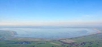
Jade Bight
For some time, there were three permanent connecting branches and one flood bed between the river and the bight, forming an estuarine delta.
The most important projects prior to 1650 were the Ellenser Damm across the Schwarzes Brack in the west of the bay in 1596 to 1615 and the New Hoben-Dike in the east in 1643.
Tidal flows make the neck of Jade Bight the deepest natural channel near Germany's North Sea coast.
In 1853, the Kingdom of Prussia bought a part of the western shore of the bay from Oldenburg, in order to use the harbour as a Prussian naval base, later called Wilhelmshaven.
The foreshore areas of Jade Bight form a part of the German Wadden Sea National Parks.

Map showing Jade
Bay
(
Jadebusen
) at lower center

• blue areas = advancement of waterbodies
• green areas = growth of land
• grayish pale blue areas = sometimes flooded
• grayish lilac areas = newly gained land lost again
• grayish pink areas = regained land lost again
• brown to red lines = dikes
• bold intensive light blue line = today's coastline
• light blue lines = today's limit of mudflats
• bold pale blue lines = limit of mudflats c. 1810
• dirty lilac lines = limit of mudflats c. 1645
• light pink to light lilac, ocre and light green lines = geological soil borders.
Greenish coloured areas (except the few bluish green ones) represent new won land. Regaining of losses mostly is marked only by the dikes.
→ This map for reading: • 33 % (216 dpi) , • 50 % (144 dpi)