Jan Mayen
Other than this, economic activity is limited to providing services for employees of Norway's radio communications and meteorological stations located on the island.
There are important fishing resources, and the existence of Jan Mayen establishes a large exclusive economic zone (EEZ) around it.
[5] Norway has found large deposits of minerals along the Mid-Atlantic Ridge between Jan Mayen and southern Svalbard/Bear Island,[6] including copper, zinc, cobalt, gold and silver.
Geologists suspect significant deposits of petroleum and natural gas lie below Jan Mayen's surrounding seafloors.
[9][10] Both the LORAN transmitter and the meteorological station are located a few kilometres away from the settlement Olonkinbyen (Olonkin Town), where all personnel live.
Strong indicators exist of their presence in the Faroe Islands and Iceland before the arrival of the Vikings, and medieval Gaelic chronicles such as the famous Voyage of Saint Brendan the Abbot testify to the extensive interest in exploration at the time.
A modern-day trans-Atlantic journey proved the ability of the early navigators to reach all lands of the north Atlantic even further from Ireland than Jan Mayen – and, given favourable winds, at a speed roughly equal to that of modern yachts.
The land named Svalbarð ("cold coast") by the Vikings in the early medieval book Landnámabók may have been Jan Mayen (instead of Spitsbergen, renamed Svalbard by the Norwegians in modern times); the distance from Iceland to Svalbarð mentioned in this book is two days' sailing (with favorable winds), consistent with the approximate 550 km (340 mi) to Jan Mayen and not with the minimum 1,550 km (960 mi) to Spitsbergen.
The Dutchman Fopp Gerritsz, whilst in command of a whaling expedition sent out by the Englishman John Clarke, of Dunkirk, claimed (in 1631) to have discovered the island on 28 June and named it "Isabella".
They had assumed the latter, who named the island Maurits Eylandt (or Mauritius) after Maurice of Nassau, Prince of Orange, would report their discovery to the States General.
[25] Jan Mayen first appeared on Willem Jansz Blaeu's 1620 edition map of Europe, originally published by Cornelis Doedz in 1606.
On 15 June they met the two English ships, which Schrobop allowed to remain, on condition they gave half their catch to the Dutch.
[28] That year 200 men were seasonally living and working on the island at six temporary whaling stations (spread along the northwest coast).
Captain Outger Jacobsz of Grootebroek was asked to stay the next winter (1633/34) on Jan Mayen with six shipmates to defend the island.
While a group with the same task survived the winter on Spitsbergen, all seven on Jan Mayen died of scurvy or trichinosis (from eating raw polar bear meat) combined with the harsh conditions.
[21] The bowhead whale was locally hunted to near-extinction around 1640 (approximately 1000 had been killed and processed on the island),[21] at which time Jan Mayen was abandoned and stayed uninhabited for two and a half centuries.
The Austrian polar station on Jan Mayen Island was built and equipped in 1882 fully at Count Wilczek's own expense.
Between 1900 and 1920, there were a number of Norwegian trappers spending winters on Jan Mayen, hunting Arctic foxes in addition to some polar bears.
The four-man team on Jan Mayen stayed at their posts and in an act of defiance began sending their weather reports to the United Kingdom instead of Norway.
The British expedition commander, prompted by the loss of the gunboat, decided to abandon Jan Mayen until the following spring and radioed for a rescue ship.
Within a few days a ship arrived and evacuated the four Norwegians and their would-be reinforcements, after demolishing the weather station to prevent it from falling into German hands.
The team's radio transmissions soon betrayed its presence to the Axis, and German planes from Norway began to bomb and strafe Jan Mayen whenever weather permitted, but did little damage.
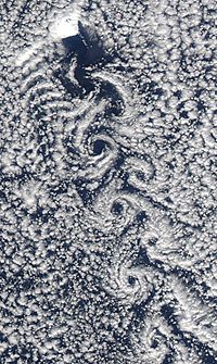
For some time scientists doubted that the Beerenberg volcano would become active, but in 1970 it erupted for about three weeks, adding another 3 km2 (1.2 sq mi) of land mass to the island.
[36] The aim of this regulation is to ensure the preservation of a pristine Arctic island and the marine life nearby, including the ocean floor.
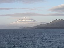
Nord-Jan has a round shape and is dominated by the 2,277 m (7,470 ft) high Beerenberg volcano with its large ice cap (114.2 km2 or 44 sq mi), which can be divided into twenty individual outlet glaciers.
Jan Mayen is featured as an easter egg in several grand strategy video games published by Paradox Interactive, such as Europa Universalis IV.
In Europa Universalis IV, typing "bearhaslanded" into the command console will spawn Jan Mayen as a country in a random location.
[45] In Hearts of Iron IV, also published by Paradox Interactive, players can play as Jan Mayen controlled by the polar bear "Grand Admiral Johan Mayan" by completing an elaborate easter egg chain as Poland during the Second World War.
[47] In the video game Uboat, the player can be assigned a mission where he has to set-up a weather station in an uninhabited part of the island.
The 2022 film Tales of Jan Mayen, directed by Hugo Pettit, documents the recreation of the 1921 British expedition to the summit of Mount Beerenberg.