Jervis Bay
Archaeological finds at Burrill Lake, 55 kilometres south of Jervis Bay, provide evidence of Aboriginal occupation dating back 20,000 years.
[9][10] In August 1791, Lieutenant Richard Bowen, aboard the convict transport ship Atlantic, part of the Third Fleet, sailed into the bay and named it in honour of Admiral John Jervis, under whom he had served.
[9][11][12] In November 1791 Master Matthew Weatherhead entered the bay aboard Matilda, which had also been part of the Third Fleet, in order to undertake repairs to the ship.
[15] A separate population of Aborigines, whom settlers called "the Jervis Bay tribe" — the Wandandian people[16] — remained on their traditional lands on the bank of Currambene Creek, near Huskisson, and around St Georges Basin, until well into the 20th century.
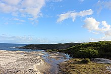
[29] The bay took on its present appearance around 4000 BC after the sea levels had risen 120 metres (390 ft), and as sand dune barriers created the southern peninsula.
[30] Much of the rock in Jervis Bay is part of the Sydney Basin sandstone formation, which is 280-225 million years old, although lower areas are overlain with Tertiary-era sediments.
[35] Jervis Bay is known for recreational fishing, kayaking, paddleboarding, sailing[36] and scuba diving, with tour operators departing from Huskisson and amateurs using boat ramps at bayside towns and camp sites.
Popular diving sites include The Labyrinths, Gorgonian Wall, Point Perpendicular, a submerged Fairey Firefly aeroplane, scallop beds, Middle Ground, Ten Fathom Reef, and Bowen Island.
They also found abundant Angasi oysters and scallops growing on the lines which they dropped at first, but the industry focus is on the blue mussels, which have a high ratio of meat to shell.
The potential of growing seaweeds for commercial use is also being explored, and Shoalhaven City Council is investing A$2.3 million to develop a wharf, boat maintenance facility and other infrastructure needed to service the industry.
With an annual rainfall around 1,200 mm, it is wetter than other areas in the South Coast due to its exposed eastward location on a peninsula facing the Tasman Sea, thus making it more susceptible to moist easterly flows.