Johannes Rebmann
[2] News of Rebmann's discovery was published in the Church Missionary Intelligencer in May 1849, but disregarded as mere fantasy for the next twelve years.
The Geographical Society of London held that snow could not possibly occur let alone persist in such latitudes and considered the report to be the hallucination of a malaria-stricken missionary.
Expeditions to Tanganyika between 1861 and 1865, led by the German Baron Karl Klaus von der Decken, confirmed Rebmann's report.
[4] Their work there is also thought to have had effects on future African expeditions by Europeans, including the exploits of Sir Richard Burton, John Hanning Speke, and David Livingstone.
[6][9] Together with fellow missionary Johann Ludwig Krapf, Rebmann traveled in 1846 by a ship called "Arrow" to East Africa, where he worked in what is now Kenya, as well as at various other locations.
Krapf noted (what he called) the "surge of Islam" that was going through Africa, and wanted to make some sort of Christian standing against its religious influence on the people of the continent.
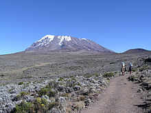
[12] Sometime during their journey or their stay in the region, Rebmann and Krapf learned of a great mountain referred to as 'Kilimansharo', which reached the clouds and which was 'capped in silver'.
The two men, like most Europeans at the time, were under the impression that snow and ice could not exist so close to the equator, and failed to realize the significance of the mountain being 'topped with silver'.
My Guide called the white which I saw merely 'Baridi,' cold; it was perfectly clear to me, however, that it could be nothing else but snow.Mount Kenya was sighted by Krapf in the next year, on December 3, 1849.
The finding of this mountain was also met with disbelief in Europe, but the effect of these sightings by Europeans was enough to trigger further investigation into other areas of Africa, thereby stimulating a growth of scientific (among other fields) knowledge of the regions, people, history, and geography of the African continent.
[17] In addition, after meeting a Swahili-speaking slave known as Salimini, originally from Malawi, in 1853, he compiled the first ever Chichewa language dictionary, which was eventually published in 1877.
[12] The basis for the map was prepared by the missionary Jakob Erhardt from the reports of his companions Krapf and Rebmann, and from verbal information that he had acquired from local people.
[20] On the map, several subtle but interesting things can be discovered, including, in the northeast section of the cartograph, a reference to a stream flowing into Lake Victoria, then known by the missionaries as "the Ukerewa".
This note is probably the first known text referring to the drinking water, found primarily around Mount Meru, which has a high content of fluorine and causes a yellow-brown stain to the incisors which cannot be removed.
Longitude delineating the probably position and extent of the Sea of Uniamesi as being the continuation of the Lake Niasa and exhibiting the numerous heathen-tribes situated to the East and West of that great Inland-sea together with the Caravan routes leading to it and into the interior in general.
Society in East Africa Kisaludini March 14, 1855.Having almost lost his eyesight for unknown reasons, Rebmann went back to Europe in September 1875.