John Speed map of Canaan
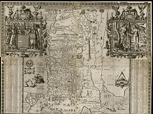
The John Speed map of Canaan, formally titled "Canaan as it was possessed both in Abraham and Israels dayes with the stations and bordering nations," is an ancient wall map of the Land of Israel drawn by the English historian and cartographer John Speed in 1595.
The map also includes historical-biblical details: The story of The Exodus - the Israelites' route out of Egypt with illustrations of miniature figures and events along the route, the formation of the land of Israel with the borders of the Israeli tribes in marking with striated lines, and the story of Jonah and the whale illustrated off shore from the city Ascalon with the whale opening his mouth in order to swallow the prophet Jonah.
On the sides of the bottom right and left quadrants appear two tables of references, according to longitude and latitude lines of sites on the map.
The big cartouche at the top left shows the biblical Israeli leaders Moses and Aaron placing their hands on Israel's Tablets of the Law with the Ten Commandments inscribed in Hebrew.
The small cartouche at the bottom left quadrant shows a heraldic eagle and an inscription to sir Robert Cotton who encouraged Speed to start drawing maps.