Jordan River (Utah)
Members of the Desert Archaic Culture were the earliest known inhabitants of the region; an archaeological site found along the river dates back 3,000 years.
Mormon pioneers led by Brigham Young were the first European American settlers, arriving in July 1847 and establishing farms and settlements along the river and its tributaries.
The growing population, needing water for drinking, irrigation, and industrial use in an arid climate, dug ditches and canals, built dams, and installed pumps to create a highly regulated river.
Once the home of bighorn sheep and beaver, the contemporary river is frequented by raccoons, red foxes, and domestic pets.
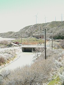
The Utah National Guard base at Camp Williams lies on the western side of the river through much of the Jordan Narrows.
Parley's, Emigration, and Red Butte Creeks converge from the east through an underground pipe, 14.2 miles (22.9 km) from the mouth.
[13] The Jordan Subbasin, as defined by the United States Geological Survey, is located entirely within Salt Lake and Utah counties in a roughly rectangular area of 791 square miles (2,050 km2).
The Wasatch Range rises on the east, with a high point of 11,100 feet (3,400 m) above sea level at Twin Peaks, near the town of Alta.
At its greatest extent, Lake Bonneville reached an elevation of 5,200 feet (1,600 m) above sea level and had a surface area of 19,800 square miles (51,000 km2).
The State of Utah has scattered land holdings of 9,800 acres (40 km2) throughout the subbasin and owns the beds of all navigable streams and lakes.
[24] The next recorded inhabitants, between 400 A.D. to around 1350 A.D., were the Fremont people, composed of several scattered bands of hunters and farmers living in what is now southern Idaho, western Nevada and most of Utah.
[25] The disappearance of the Fremont people has been attributed to both changing climatic conditions, which put an end to favorable weather for farming, and to the arrival of ancestors to the present-day Ute, Paiute, and Northwestern Shoshone.
[29] In 1776, Franciscan missionary Silvestre Vélez de Escalante was trying to find a land route from Santa Fe, New Mexico, to Monterey, California.
His party included twelve Spanish colonials and two Utes from the Utah Valley Timpanogots band who acted as guides.
In October 1824, Provost's party was lured into a Shoshone camp somewhere along the Jordan River, where they were attacked in retaliation for the murder of a local chief.
[40] In 1850, Captain Howard Stansbury of the United States Army Corps of Topographical Engineers traveled the entire length of the Jordan River,[41] surveying[42] and making observations of the wildlife.
[44] Around the year 1887 at Bingham Canyon in the Oquirrh Mountains, low-grade copper deposits were discovered and mining claims were filed.
[50] Alterations of the Jordan River watershed began two days after the Mormon Pioneers arrived in the Salt Lake Valley when water was diverted from City Creek for irrigation.
[60] Twice, during the droughts of 1934 and 1992, Utah Lake levels dropped so low that the pumps were rendered useless and the Jordan River actually ran dry.
The river was also shifted to opposite sides of the flood plain in Midvale and Murray as part of local smelter operations.
Big Cottonwood, Parley's, Emigration and City creeks flowed down sand-bag lined streets in order to manage the overflowing streams.
[75] Before the area was urbanized, mammals such as bighorn sheep, mule deer, coyote, wolves, beaver, muskrat and jackrabbits would have been seen along the river.
The final count of the hunt included "two bears, two wolverines, two wildcats, 783 wolves, 409 foxes, 31 minks, nine eagles, 530 magpies, hawks and owls, and 1,026 ravens.
"[76] None of the original large mammals is found along the Jordan River today; they have, for the most part, been replaced by raccoons, red foxes and domestic pets.
[84] Once-common native species such as the willow flycatcher, gray catbird, warbling vireo, American redstart, black tern, and yellow-billed cuckoo are no longer found along the river.
The most common species now found are the black-billed magpie, mourning dove, western meadowlark, barn swallow, and the non-native ring-necked pheasant and starlings.
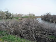
Plant species such as foxtail barley, saltgrass, rabbitbrush, cattails and other reeds are still found in small pockets along the river.
A 72-square-mile (190 km2) plume of lead, arsenic and sulfates (covering 9 percent of the watershed) currently contaminates the ground water from the mine site all the way to the Jordan River.
[102] The Jordan River Parkway was originally proposed in 1971 as a flood control measure with two reservoirs, restoration of wetlands, shoreline roads for cars, walking trails, and parks.
[103][104] By 1986, $18 million had been used to purchase lands around the Jordan River and to construct the Murray Golf Course, several smaller parks and about 4 miles (6.4 km) of canoe runs and trails.