Salt Lake County, Utah
The future Salt Lake County area was settled by European Americans in 1847 when Mormon pioneers of the Church of Jesus Christ of Latter-day Saints fled religious persecution in the East.
[9] The intermediate years between 1857 and 1869 passed with no federal surveyors, the LDS Pioneers completed plats, deeds, and surveys of the county in order to homestead and collect taxes.
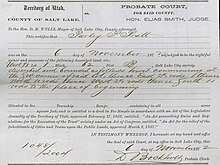
The process to adjudicate the certificates took place over several years in 1871–1873, through the county Probate Court, overseen by judge Elias Smith.
In 1862, Fort Douglas was established on the eastern bench, near the current site of the University of Utah, as the federal government wanted to ensure the loyalty of the territory during the American Civil War.
During the late 19th century, mines were established in the Wasatch mountains, most notably around Alta (and nearby Park City in Summit County).
The federal government established other major defensive installations along the Wasatch Front and in the Great Salt Lake Desert during World War II, which stimulated the economy and brought more people to the area, establishing Utah as a major military center that benefited from federal investment.
In the nationwide suburban boom of the late 1940s, 1950s, and early 1960s, such cities as South Salt Lake, Murray, Midvale, and much of the east side of the valley grew rapidly.
Huge residential tracts were developed through the center of the valley, and within ten years, the entire area had been converted from farmland into sprawling bedroom communities in Salt Lake City.
The only remaining mining town in the county is Copperton, located southwest of West Jordan, with approximately 800 residents.
On the north and east benches, houses have been built halfway up the mountain to the boundary of the national forest, assuming greater risk from wildfires.
In the far west, southwest, and northwest, rural areas still exist, but rapid growth threatens what remains of the natural environment in the valley.
Of these, only the connection to Davis County to the north is wide enough and flat enough to accommodate transportation routes without reliance on earthworks.
These storms can cause contrasting emergencies of flash floods and wildfires (due to dry lightning and powerful winds).
This weather event lasts from a few days to a month in extreme cases and is caused when an area of high pressure forms over the Great Basin.
The racial makeup of the county was 70.3% non-Hispanic White, 2.2% Black, 1.4% Native American, 4.6% Asian, 1.8% Pacific Islander, and 2.9% from two or more races.
The 2005 American Community Survey indicated that 11.4% of Salt Lake County's population living in households (as opposed to group arrangements such as college dormitories) spoke Spanish at home.
[30] The first governing administrative body of the county was made up of the probate court and judge, Elias Smith, and three selectmen: Samuel Moore, Reuben Miller, and J.C. Wright.
Though the judge was removed when the court was abolished upon statehood, the Selectmen stayed on in their offices until elections to fill the new commission seats were held.
See district maps Like most of Utah, Salt Lake County has traditionally favored candidates from the Republican Party.
In 2008, however, Democrat Barack Obama won Salt Lake County by an extremely narrow margin, 48.17% to 48.09%, over Republican John McCain—a difference of 296 votes.
Since World War II, defense industries in the region have also played a very important role in the economy due to its strategic central location in the Western United States, as well as the largely uninhabited and desolate Great Salt Lake Desert to the west (used for training, weapons testing, and storage of hazardous materials).
[100] Union Pacific controls all long-distance freight tracks into the county, though the Utah Railway, BNSF, and Salt Lake, Garfield, and Western have long-standing trackage rights.
The Salt Lake City Southern and Savage Bingham and Garfield railroads operate totally within the county.
The Utah Transit Authority's (UTA) FrontRunner commuter rail line provides all-day service to Ogden (with select peak hour trips going to Pleasant View) to the north (via Davis County) and Provo to the south.
I-80 continues west past the Salt Lake City International Airport and east through Parley's Canyon and into the Wasatch Range.
I-215 directly serves many of the suburbs of Salt Lake City in the western, central, and eastern portions of the valley in a 270° loop.
The Legacy Parkway opened in 2008 to connect with I-215 at the north end of the valley, providing an alternative route into Davis County to alleviate congestion.
The Mountain View Corridor is a limited-access highway across the southwestern part of the county; construction began in 2010 and it was put into operation in stages.
The Utah Transit Authority operates bus routes throughout the valley and along the Wasatch Front, to Park City and Tooele, and to the ski resorts in winter.
The Bonneville Shoreline Trail runs along the face of the Wasatch mountains, skirting the edge of the built up areas of the east bench, though there are large gaps in the central part of the county.