Jordanian Highlands
It extends north and south through the western portion of the country, between the Red Sea-Dead Sea depression to the west and a plateau to the east.
The highlands are bounded on the north by the deeply-incised Yarmouk River valley, which forms part of the border between Jordan and Syria.
[2] The highlands were formed by relatively recent (Neogene–Quaternary) tectonic events, as the northwestern rim of the Arabian Plate was uplifted as it moves northward and clockwise.
Towards the north and west and at higher elevations a Mediterranean climate prevails, with mild rainy winters and hot, dry summers.
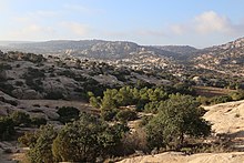
Forests and woodlands in the southern highlands include Quercus calliprinos, cypress (Cupressus sempervirens), juniper (Juniperus phoenicea), and pistachio (Pistacia atlantica).
[3][4] A semi-arid steppe zone lies between 600 and 800 meters elevation on the eastern slope of the mountains, where rainfall is between 200 and 350 mm annually.
There is a narrower steppe zone on the western slopes between the upper-elevation Mediterranean forests and the lower-elevation deserts of the Jordan Rift Valley.
[4] Desert vegetation is found in the Jordan Rift Valley, the southern highlands, and the eastern plateau where average annual rainfall is 200 mm or less.