Kadavu Island
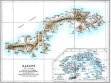
Its main administrative centre is Vunisea, which has an airport, a high school, a hospital, and a government station, on the Namalata Isthmus where the island is almost cut in two.
The tallest mountain is Nabukelevu, also known as Mount Washington, which stands at 805 metres (2,641 feet) high, on the western end of the island.
There are few roads, and the local economy is largely dependent on subsistence farming, supplemented by exports to Viti Levu.
Galoa Harbour became a regular port of call for vessels carrying mail between Sydney, San Francisco, and Auckland.
The most famous theory is that the Kadavu people came from different parts of Fiji through Beqa and crossed through Deuba village.
These birds have survived on Kadavu due to the richness and abundance of natural resources as well as the climatic conditions of the island.
The most famous bird is the Kadavu crimson shining-parrot, which stands out from other parrots in the country, with its blue-collar at the back of the neck.
The Kadavu archipelago lies on Fiji's earthquake belt and cyclone path, making it prone to natural disasters.
Despite these difficulties, Kadavuans have developed resilience and achieved prominence in various fields, holding top positions across the country.
Wherever in the world they may find themselves, the people maintain a strong connection to their homeland and pride in their identity as "Kai Kadavu."