Kahoʻolawe
[5] Kahoʻolawe is relatively dry, with an average annual rainfall of less than 26 in (66 cm)[6] resulting from a combination of being too low to generate much orographic precipitation from the northeastern trade winds and lying in the rain shadow of eastern Maui's 10,023-foot-high (3,055 m) volcano, Haleakalā.
After decades of protests, the U.S. Navy ended live-fire training exercises on Kahoʻolawe in 1990, and the whole island was transferred to the jurisdiction of the state of Hawaii in 1994.
Puʻu Moiwi, a remnant cinder cone,[14] is the location of the second-largest basalt quarry in Hawaiʻi, and this was mined for use in stone tools such as koʻi (adzes).
[15] Originally a dry forest environment with intermittent streams, the land changed to an open savanna of grassland and trees when inhabitants cleared vegetation for firewood and agriculture.
After the arrival of missionaries from New England, the Kingdom of Hawaiʻi under the rule of King Kamehameha III replaced the death penalty with exile, and Kahoʻolawe became a men's penal colony sometime around 1830.
From 1910 to 1918, the Territory of Hawaii designated Kahoʻolawe as a forest reserve in the hope of restoring the island through a revegetation and livestock removal program.
In 1918, the rancher Angus MacPhee of Wyoming, with the help of the landowner Harry Baldwin of Maui, leased the island for 21 years, intending to build a cattle ranch there.
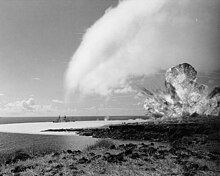
On December 7, 1941, after the Imperial Japanese Navy attacked Pearl Harbor and Oahu, the U.S. Army declared martial law throughout Hawaii, and it used Kahoʻolawe as a place to train American soldiers and Marines headed west to engage in the War in the Pacific.
The use of Kahoʻolawe as a bombing range was believed to be critical, since the United States was executing a new type of war in the Pacific Islands.
Their success depended on accurate naval gunfire support that suppressed or destroyed enemy positions as U.S. Marines and soldiers struggled to get ashore.
During the Korean War, warplanes from aircraft carriers played a critical role in attacking enemy airfields, convoys, and troop staging areas.
[21] The effort to regain Kaho‘olawe from the U.S. Navy began as a new wave of political awareness and activism was inspired within the Hawaiian community.
Over 50 people from across the Hawaiian islands, including a range of cultural leaders, gathered on Maui with the goal of "invading" Kahoʻolawe on January 6, 1976.
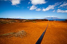
As part of the soil conservation efforts, Mike Ruppe, an Army Specialist on loan from Schofield Barracks, plus other military personnel, laid lines of explosives, detonating them to break the hardpan so that seedling trees could be planted.
Used car tires were taken to Kahoʻolawe and placed in miles of deep gullies to slow the washing of red soil from the barren uplands to the surrounding shores.
As required by Title X, the U.S. Navy retained access control to the island until the clearance and environmental restoration projects were completed, or until November 11, 2003, whichever came first.
In July 1997, the Navy awarded a contract to the Parsons/UXB Joint Venture to clear unexploded ordnance from the island to the extent funds were provided by Congress.
By state law, Kahoʻolawe and its waters can be used only for Native Hawaiian cultural, spiritual, and subsistence purposes; fishing; environmental restoration; historic preservation; and education.
[32] The restoration of Kahoʻolawe will require a strategy to control erosion, re-establish vegetation, recharge the water table, and gradually replace alien plants with native species.
Species used for revegetation include ʻaʻaliʻi (Dodonaea viscosa), ʻāheahea (Chenopodium oahuense), kuluʻī (Nototrichium sandwicense), Achyranthes splendens, ʻūlei (Osteomeles anthyllidifolia), kāmanomano (Cenchrus agrimonioides var.
The plan outlines the restoration of Kaho‘olawe Island through the removal of feral cats (Felis catus), rats (Rattus exulans) and mice (Mus musculus).