Kalinga (region)
It is generally defined as the eastern coastal region between the Ganges and the Godavari rivers, although its boundaries have fluctuated with the territory of its rulers.
At its widest extent, the Kalinga region also included parts of present-day Chhattisgarh, extending up to Amarkantak in the west.
The medieval era rulers to rule over the Kalinga region were the Suryavamsa Gajapatis, Bhoi dynasty,[3] Paralakhemundi Gangas[4][5] and the zamindaris of Ganjam and Vizagapatam.
[7] According to political scientist Sudama Misra, the Kalinga janapada originally comprised the area covered by the Puri and Ganjam districts.
However the simple mention of Ganga as the northern boundary of Kalinga by Pliny as stated above and Mahabharata talking about Baitarani, a river which is north of Mahanadi and borders Odisha and Jharkhand at one point and falls into Bay of Bengal in Bhadrak district of Odisha, passing through Kalinga, nullifies this claim.
In the ancient Indian literature, the Kalinga region is associated with the Mahendragiri mountain located in the Ganjam district of Odisha, near its border with Andhra Pradesh.
[20] The Shailodbhavas who emerged as Maha-Samanta of Shashanka declared themselves independent after 620 CE and acquired the title of Sakala-Kalingādhipati ("Lord of whole of Kalinga").
On the west, Kaliṅga had established its suzerainty over the tribes in inland hills so that its authority reached till the Amarakaṇṭaka range.
[28] Its capital in the ancient times was the city of Dantakura or Dantapura (now Dantavaktra fort near Chicacole in the Srikakulam district, washed by the river Languliya or Langulini).
[28] The kingdom of Kaliṅga was already existent at the time of the Brahmana texts, which mention its king Karaṇḍu as a contemporary of Nagnajit of Gāndhāra and of Bhīma of Vidarbha.
[29] According to Mahabharata and some Puranas, the prince 'Kalinga' founded the Kalinga kingdom, in the current day region of coastal Odisha, including the North Sircars.
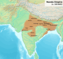
[35] Nandas control of Kalinga region is corroborated by the Hathigumpha inscription of the later king Kharavela (c. 2nd or 1st century BCE).
It is described as "Calingae" in Megasthenes' Indica (3rd century BCE): The Prinas and the Cainas (a tributary of the Ganges) are both navigable rivers.
After the final battle near the Dhauli hills, the capital Tosali fell to the Mauryas where the headquarters of the Mauryan province of Kalinga was also located.
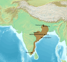
After the decline of the Mauryan Empire, the region came under the control of the Mahameghavahana family, whose king Kharavela described himself as the "supreme Lord of Kalinga".
After the Gupta withdrawal, it was ruled by several minor dynasties, whose rulers bore the title Kalingadhipati ("Lord of Kalinga").
[41] During the 8th–10th centuries, the Bhauma-Kara dynasty ruled the region, although they called their kingdom "Tosala" (derived from Tosali, the ancient capital of Kalinga).
[42] The Somavamshis ruled parts of present-day Odisha in eastern India between the 9th and the 12th centuries with their capitals included Yayatinagara and Abhinava-Yayatinagara (modern Jajpur).
Following repeated invasions from the northern regions, Narasimhadeva I, the son of Anangabhima Deva III, invaded southern Bengal in 13th cen., defeated its ruler, captured the capital (Gauda), and built the Sun Temple at Konark to commemorate his victory.
Mukunda Deva who traced his descent from the Eastern Chalukyas of Vengi[48] rebelled and killed the last two successors of the Bhoi dynasty and declared himself an independent ruler in 1559 on Northern Odisha coast over the Bhoi dynasty's territories but Sulaiman Khan Karrani formed a kingdom in the region of Bengal which proved a potential threat to Mukunda Deva.
[49] The fall of the Gajapatis meant the weakening of the centralised authority in the region and the subsequent fragmentation and independence of the tributary and feudal states.
Kaundinya I, who became the co-founder of the Funan kingdom (centered in modern Cambodia) after he married the local Nāga princess Soma also has his origins from the ancient Kalinga region.
Burma went by the name of Kalinga-rattha (likely observed in the old Indo-Chinese records for Pegu) and there is evidence of very early merchant settlements and Buddhist missions in the southern Mon regions and by the 2nd century CE, the rule of Kalinga migrants centered around Kale, the Arakan River valley and Pegu, around the Gulf of Martaban.
[34] In the Philippines according to Eric Casino, a king of Butuan was called Kiling; Casino posited that the king was not of Visayan origin but was rather of Indian origin, basing solely on the likelihood that the name Kiling was the same as the Malay term Keling (albeit this term is pronounced with a schwa) which refers to Indians.