Kallang River
[1] It originates in the planning area of Central Water Catchment, flows in a southeast direction through Bishan and Toa Payoh, before finally arriving in Kallang.
Kallang River was also the place, where in the early days the Bugis traders from Sulawesi (Celebes) unloaded their cargoes of spices and tortoise shells, gold dust and slaves from their palari or their leteh-leteh.
The Bukit Timah Second Diversion Canal (Chinese: 武吉知马第二分水渠) is a canalised river flowing from Whampoa to Kallang, following closely the path of the Pan Island Expressway (PIE).
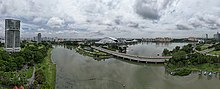
In April 2006, the Singapore government announced plans to give a 200-metre stretch of the Kallang River at Kolam Ayer a S$2.5 million facelift.
By August 2007, the Kolam Ayer stretch of the river was transformed to include more greenery, floating decks, pathways and boardwalks for recreational activities.
Officially opened on 17 March 2012 by Prime Minister Lee Hsien Loong, the meandering river's capacity is now 40% more than when it was a canal.
Besides slowing down rainwater, it now also offers residents a new recreational experience – soft planted river banks encourage people to get close to the water.