Kannur
Kannurkari (Female) Kannur (Malayalam: [kɐɳːuːr] ⓘ), formerly known in English as Cannanore, is a City and municipal corporation in the state of Kerala, India.
It is the administrative headquarters of the Kannur district and situated 274 kilometres (170 mi) north of the major port city and commercial hub Kochi and 137 kilometres (85 mi) south of the major port city and a commercial hub, Mangalore.
During the period of British colonial rule in India, when Kannur was a part of the Malabar District (Madras Presidency), the city was known as Cannanore.
[7] As of 2011 census, Kannur Municipal Corporation, the local body which administers mainland area of city, had a population of 232,486.
The earliest evidence of human habitation in the region are rock-cut caves and megalithic burial sites of the Neolithic age.
The Taliparamba-Kannur-Thalassery area abounds in rock-cut caves, dolmens, burial stone circles and menhirs, all of megalith.
Kannur District was the seat of powerful kingdom based at Ezhimala in the Sangam period (1st–5th century CE).
[14] Pliny the Elder (1st century CE) states that the port of Tyndis was located at the northwestern border of Keprobotos (Chera dynasty).
[22] It is said that Nannan, the most renowned ruler of Ezhimala dynasty, took refuge at Wayanad hills in the 5th century CE when he was lost to Cheras, just before his execution in a battle, according to the Sangam works.
[22] According to Kerala Muslim tradition, Kannur along with surrounding Madayi and Dharmadom were home to three of the oldest mosques in the Indian subcontinent.
[28] Ezhimala kingdom was succeeded by Mushika dynasty in the early medieval period, most possibly due to the migration of Tuluva Brahmins from Tulu Nadu.
The Mushika-vamsha Mahakavya, written by Athula in the 11th century, throws light on the recorded past of the Mushika Royal Family up until that point.
[30] The kingdom of Kolathunadu, who were the descendants of Mushika dynasty, at the peak of its power reportedly extended from Netravati River (Mangalore) in the north[29] to Korapuzha (Kozhikode) in the south with Arabian Sea on the west and Kodagu hills on the eastern boundary, also including the isolated islands of Lakshadweep in the Arabian Sea.
[31] The Arabic inscription on a copper slab within the Madayi Mosque in Kannur records its foundation year as 1124 CE.
The Kolathunadu in the late medieval period emerged into independent 10 principalities i.e., Kadathanadu (Vadakara), Randathara or Poyanad (Dharmadom), Kottayam (Thalassery), Nileshwaram, Iruvazhinadu (Panoor, Kurumbranad etc., under separate royal chieftains due to the outcome of internal dissensions.
[33] The Nileshwaram dynasty on the northernmost part of Kolathiri dominion, were relatives to both Kolathunadu as well as the Zamorin of Calicut, in the early medieval period.
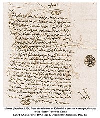
The Portuguese explorer Vasco da Gama arrived at Kappad Kozhikode in 1498 during the Age of Discovery, thus opening a direct sea route from Europe to South Asia.
[36] In 1501 a Portuguese factory was planted here by Pedro Álvares Cabral, and in 1502 da Gama made a treaty with the Raja.
[7] The St. Angelo Fort at Kannur was built in 1505 by Dom Francisco de Almeida, the first Portuguese Viceroy of India.
They modernised the fort and built the bastions Hollandia, Zeelandia, and Frieslandia that are the major features of the present structure.
The island of Dharmadom near Kannur, along with Thalassery, was ceded to the East India Company as early as 1734, which were claimed by all of the Kolattu Rajas, Kottayam Rajas, Mannanar[38] and Arakkal Bibi in the late medieval period, where the British initiated a factory and English settlement following the cession.
[39][33] Then the East India Company captured the fort Kannur in 1790 and used it as one of their major military stations on the Malabar Coast.
[40] Initially the British had to suffer local resistance against their rule under the leadership of Kerala Varma Pazhassi Raja, who had popular support in Thalassery-Wayanad region.
[14] The guerrilla war launched by Pazhassi Raja, the ruler of Kottayam province, against the East India Company had a huge impact on the history of Kannur.
Changes in the socio-economic and political sectors in Kerala during the initial decades of the 20th century created conditions congenial for the growth of the Communist Party.
Extension of English education initiated by Christian missionaries in 1906 and later carried forward by government, rebellion for wearing a cloth to cover upper parts of body, installing an idol at Aruvippuram in 1888, Malayali Memorial in 1891, establishment of SNDP Yogam in 1903, activities, struggles etc.
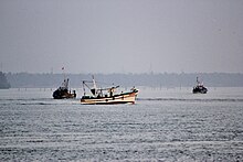
Kannur is located north of Kozhikode, south of Kasargod and Mangalore, west of the Western Ghat regions of Kodagu and Wayanad, and east of the Laccadive Sea.
Apart from regular law and order, the city police comprise the traffic police, bomb squad, dog squad, fingerprint bureau, women's cell, juvenile wing, narcotics cell, riot force, armed reserve camps, district crime records bureau and a women's station.
[57] The snacks include unnakkaya (deep-fried, boiled ripe banana paste covering a mixture of cashew, raisins and sugar),[59] pazham nirachathu (ripe banana filled with coconut grating, molasses or sugar),[59] muttamala made of eggs,[57] chatti pathiri, a dessert made of flour, like a baked, layered chapati with rich filling, arikkadukka,[60] and more.
Literature: Sukumar Azhikode, Oyyarathu Chandu Menon, Cherusseri Namboothiri, N. Prabhakaran, T. Padmanabhan, T. K. D. Muzhappilangad Sports: Manuel Frederick, Jimmy George, V. P. Sathyan, Denson Devadas, C. K. Vineeth, Sahal Abdul Samad, Tintu Luka, Chundangapoyil Rizwan Political leaders: M. V. Raghavan, Pinarayi Vijayan, K. Karunakaran, E. K. Nayanar, K. K. Shailaja, E. Ahamed, Kodiyeri Balakrishnan, John Brittas, E. P. Jayarajan, Kadannappalli Ramachandran, K. Sudhakaran Actors: Sreenivasan, M. N. Nambiar, Malavika Mohanan, Samvrutha Sunil, Mamta Mohandas, Vineeth, Vineeth Kumar, Deepak Parambol, Sanusha, Sanoop Santhosh, Nikhila Vimal, Nivetha Thomas, Sreekala Sasidharan, Sneha Paliyeri, Anju Aravind, Athmiya Rajan, Sruthi Lakshmi, Parvathy Nambiar, Ganapathi S Poduval, Madonna Sebastian, Sana Khan, Santhosh Keezhattoor Filmmakers: Bejoy Nambiar, Salim Ahamed, Vineeth Sreenivasan, Dhyan Sreenivasan Music (Composers):Kaithapram Damodaran Namboothiri, Kannur Rajan, Deepak Dev, Ifthi, Shaan Rahman, Sushin Shyam, Sayanora Philip Music (Playback singers): Vineeth Sreenivasan, Shaan Rahman, Sushin Shyam, Sayanora Philip, Arun Alat Cinematographer: K. U. Mohanan Dancer: Shamna Kasim