Karabakh
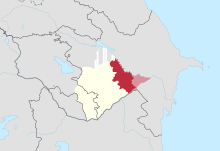
Karabakh (Azerbaijani: Qarabağ [ɡɑɾɑˈbɑɣ]; Armenian: Ղարաբաղ, romanized: Ġarabaġ [ʁɑɾɑˈbɑʁ]) is a geographic region in southwestern Azerbaijan and eastern Armenia, extending from the highlands of the Lesser Caucasus down to the lowlands between the rivers Kura and Aras.
Another theory, proposed by Armenian historian Bagrat Ulubabyan, is that, along with the "large" translation of kara,[14] the bagh component was derived from the nearby canton called Baghk, which at some point was part of Melikdoms of Karabakh within modern-day Karabakh – Dizak and the Kingdom of Syunik (in Baghk, the -k suffix is a plural nominative case marker also used to form names of countries and regions in Classical Armenian).
During the Russian Empire, the eastern lowlands where the Kura and Aras rivers meet (mostly modern-day Imishli) were also excluded, but most pre-Elisabethpol maps include that region in Karabakh.
During the period of Mongol domination, a great number of Armenians left Lowland Karabakh and sought refuge in the mountainous (Highland) heights of the region.
[23] In the fifteenth century, the German traveler Johann Schiltberger visited Lowland Karabakh and described it as a large and beautiful plain in Armenia, ruled by Muslims.
[19] The Safavid Shah ("King") Tahmasp I (r. 1524–1576) appointed the family of Shahverdi Sultan, who hailed from the Ziad-oglu branch of the Qajar tribe, as governors of Karabakh.
[26] It was also invaded and ruled by Ottoman Empire between 1578–1605 and again between 1723 and 1736, as they briefly conquered it during the Ottoman-Safavid War of 1578-1590 and during the disintegration of Safavid Iran, respectively.
Under Russian rule, Karabakh (both Lowland and Highland) was a region with an area of 13,600 km2 (5,250 sq mi), with Shusha (Shushi) as its most prominent city.
According to the statistics of the initial survey carried out by the Russians in 1823 and an official one published in 1836, Highland Karabakh was found almost overwhelmingly Armenian in population (96.7%).
[30] A decade after the Russian annexation of the region, many Armenians who had fled Karabakh during the reign of Ibrahim Khalil Khan (1730–1806) and settled in Yerevan, Ganja, and parts of Georgia were repatriated to their villages, many of which had been left derelict.
[31] The population of Karabakh, according to the official returns of 1832, consisted of 13,965 Muslim and 1,491 Armenian families, besides some Nestorian Christians and Romani people.
After the dissolution of Russian Empire Karabakh, Zangezur and Nakhchivan were disputed between newly established republics of Armenia and Azerbaijan.
The British command affirmed Khosrov bey Sultanov (an appointee of the Azerbaijani government) as provisional governor-general of Karabakh and Zangezur, pending a final decision at the Paris Peace Conference.
Karabakh Armenians accused Azerbaijan of violating the letter of the 1919 agreement and, with the support of emissaries from Armenia, in March 1920 launched an ill-fated rebellion in Shusha.
[37] The NKAO consisted of the Armenian-dominated part of historical Mountainous Karabakh[38] and many Azeri villages of this region were administratively excluded from the former.
[39] During the Soviet period, several attempts were made by the authorities of the Armenian SSR to unite it with the NKAO but these proposals never found any support in Moscow.
In February 1988, within the context of Mikhail Gorbachev's glasnost and perestroika policies, the Supreme Soviet of the NKAO voted to unite itself with Armenia.
A trilateral ceasefire agreement signed on 10 November 2020 ended the war and forced Armenia to return all of the remaining territories surrounding Nagorno-Karabakh.
[45][46] During the Russian Empire, the entire Karabakh region (mountainous and flatland) was divided into four counties (uezds) within the Elizavetpol Governorate: Jevanshir, Zangezur, Jebrail, and Shusha.
[49] However, as the Armenian notables of Karabakh often borrowed their personal names from their immediate Muslim overlords, these anthroponyms such as Kherkhan, Farukh and Seiti are usually, as Saparov narrates (citing Gaziyan and Mkrtchyan), assigned "to the Turkic toponymic landscape".
[49] Due to Karabakh's specific economic conditions, with its lowland nomads crossing into the mountains during summer across agricultural settlements, two overlapping toponymic landscapes were created over time; Armenian and Turkic.
[50] Until the arrival of the Russian Empire, these two toponymic landscapes were used concurrently by the Armenian group on one hand and the nomads consisting of Turkics (later known as Azerbaijanis) and Kurds on the other.
[50] Other place names are toponymically unrelated in relation to their respective substitution, such as the town known as Susalykh (in Turkic) with its Armenian equivalent Mokhranes.
[51] The Tsarist officials preferred the Turkic toponyms over the Armenian ones, as they, in the words of Saparov (citing the historian George Bournoutian), likely relied on the existing Persian tax records kept by the administration of the Karabakh Khanate.
[51] During the ongoing Nagorno-Karabakh conflict, both Armenia and Azerbaijan have changed the names of numerous settlements in Karabakh order to support the legitimacy of their respective territorial claims.
[51] Most renamings by the Azerbaijani government occurred during the First Nagorno-Karabakh War, as a way to, as Saparov explains "to reinstate the symbolic authority of Azerbaijan over this disputed secessionist territory and as a result targeted what they perceived as Armenian place-names".
[52] Following the Second Nagorno-Karabakh War, the Azerbaijani government successfully petitioned Google to remove Armenian place names from maps of Karabakh.