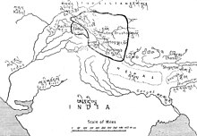
Kargil district
The pre-2024 Kargil district lies between the crest of the Great Himalaya Range and the Indus River of Ladakh.
Per the 2011 census, the Kargil tehsil, which includes the Drass and Wakha Rong valleys, contains 61% of the population of the district.
[7] Purig is believed to have been conquered, along with Ladakh proper (modern Leh district), by Lhachen Palgyigon, the son of the West Tibetan King Kyide Nyimagon, in c. 900 AD.
[12][13][c] The principality of Kartse apparently controlled the entire western Ladakh, from Mulbekh and Wanla in the east to Dras in the west, even though the extent of territory would have varied with time.
During the rule of Sultan Sikandar (r. 1394–1416), his general Rai Madari crossed the Zoji La pass and conquered Purig and Baltistan.
[19] During the invasion of Ladakh by Mirza Haidar Dughlat in 1532, Sod and Chiktan appear to have submitted, but not Kartse.
Jamyang Namgyal married Ali Mir's daughter Gyal Khatun and got reinstated as the ruler.
Their son Sengge Namgyal again rejuvenated Ladakh to old glory and in fact went further by annexing the kingdom of Guge in west Tibet.
In 1638, emperor Shah Jahan sent a force to intervene in Baltistan and installed Ali Mir's son Adam Khan as the ruler.
Marching from Kishtwar, Zorawar Singh reached Purig and defeated the Bhotia leader Mangal at Sankoo in August 1834.
[30] Following the First Anglo-Sikh War and the Treaty of Amritsar (1846), Gulab Singh was made the Maharaja of the newly carved-out princely state of Jammu and Kashmir under British suzerainty.
During the Indo-Pakistani War of 1947, pitched battles were fought around Kargil, and the entire area including Drass and Zoji La Pass initially coming under the control of Gilgit Scouts.
By November 1948, the Indian troops reclaimed all of Kargil and Leh tehsils and some portions of the Kharamang ilaqa bordering the Dras river.
During the Indo-Pakistani War of 1971 the entire Kargil region including key posts was captured by Indian troops under leadership of Col. Chewang Rinchen.
[35][better source needed] To straighten the line of control in the area, the Indian Army launched night attacks when the ground temperatures sank to below −17 °C and about 15 enemy posts located at height of 16,000 feet and more were captured.
[36] After Pakistan forces lost the war and agreed to the Shimla Agreement, the strategic areas near Kargil remained with India.
Kargl and Leh continue to be the two districts of Ladakh, with the Kargil town designated as a joint capital of the union territory.
[38] Kargil district is situated in the deep south-western part of the Himalayas, giving it a cool, temperate climate.
Sub-Divisions (5): Drass, Kargil, Shakar-Chiktan, Sankoo, Zanskar (Padum) Tehsils (8): Drass, Kargil, Shakar-Chiktan, Shargole, Sankoo, Trespone (Trespone), Taisuru, Zanskar (Padum) Blocks (14): Drass, Kargil, Shakar, Chiktan, Shargole, Sankoo, Trespone, Saliskote, Gund Mangalpore, Taisuru, Padum, Lungnaq, Cha, Zangla Each block consists of a number of panchayats.
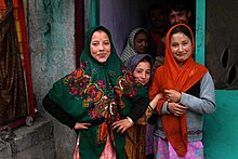
Most of the district's Muslims are found in the north (Kargil town, Drass, and the lower Suru valley).
At least until recently, some Kargilis, especially those of the Agha families (descendants of Syed preachers who were in a direct line descent from the Islamic prophet, Muhammad) went to Iraq for their education.
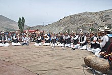
Local folk songs, which are called rgya-glu and balti ghazals, are still quite popular and are performed enthusiastically at social gatherings.
During my research I have learnt about the tremendous decline in wildlife sightings since the 1999 Kargil war, so much so that even the common resident birds had disappeared.
"[57][58][59] Besides the endangered species, various birds are commonly seen in summer: National Highway 1D, connecting Srinagar to Leh, passes through Kargil.
This highway is typically open for traffic only from May to December due to heavy snowfall at the Zoji La.
There is a partially paved road leading from Kargil south to Zanskar, which is also only open only from June to September.
India and Pakistan have both considered linking the Pakistani town of Skardu to Kargil with a bus route to reunite the Ladakh families separated by the line of control since 1972.
[62] Kargil is connected to the rest of India by high-altitude roads which are subject to landslides and are impassable in winter due to deep snows.
Upgradation of this road is going on to reduce the time travel between Kargil and Padum, tehsil headquarters of Zanskar region.
[63] The Nimmu–Padam–Darcha road is a major axis through Zanskar in Kargil district, connecting Lahaul in Himachal with Leh.