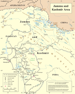
Line of Control
The part of the former princely state under Indian control is divided into the union territories of Jammu and Kashmir and Ladakh.
[5] Another ceasefire line separates the Indian-controlled state of Jammu and Kashmir from the Chinese-controlled area known as Aksai Chin.
The agreement declared that "neither side shall seek to alter it unilaterally, irrespective of mutual differences and legal interpretations".
[10] In 2000, US President Bill Clinton referred to the Indian subcontinent and the Kashmir Line of Control, in particular, as one of the most dangerous places in the world.
[11][12] The LoC from Kargil to Gurez comprises mountain passes and valleys with small streams and rivers.
[14] In 2018, two corps and a number of battalions of the Border Security Force manned the Indian side of the LoC.
[19] Military personnel on both sides risk being shot by snipers in moving vehicles, through bunker peepholes and during meals.
[35] Both civilians and military personnel on both sides have died in mine and improvised explosive device (IED)-related blasts, and many more have been injured.
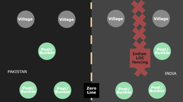
[38] The posts and bunkers allow soldiers to sleep, cook, and keep a watch on enemy positions round the clock.
The barrier, referred to as an Anti-Infiltration Obstacle System (AIOS), consists of double-row of fencing and concertina wire 8–12 feet (2.4–3.7 m) in height, and is electrified and connected to a network of motion sensors, thermal imaging devices, lighting systems and alarms.
[46] The total number between the fence and zero line on the Indian side is estimated to be 60 villages and at least one million people are spread over the districts adjacent to the LoC from Rajouri to Bandipora.
[52] Pakistan and India officially designated five crossing points following the 2005 Kashmir earthquake—Nauseri-Tithwal; Chakoti-Uri; Hajipur-Uri; Rawalakot-Poonch and Tattapani-Mendhar.
[53][54][55] According to Azad Jammu and the Kashmir Cross LoC Travel and Trade Authority Act, 2016, the following crossing points are listed:[56][57] Trade points include: Chakothi – Salamabad and Rawalakot (Titrinote) – Poonch (Chakkan-da-Bagh).
[61] The Indian and Pakistani military use these crossing points for flag meetings and to exchange sweets during special occasions and festivals.
[70] The Salamabad crossing point, or the Kamran Post, is on the road between Chakothi and Uri in the Baramulla district of Jammu and Kashmir along the LoC.
[76] A road connects Kotli and Tatrinote on the Pakistan side of the LoC to the Indian Poonch district of Jammu and Kashmir through the Chakan Da Bagh crossing point.
Banking facilities and a trade facilitation centre are being planned on the Indian side for the benefit of traders.
[82] In certain locations, women on the Pakistan side on the LoC have been instrumental in influencing infiltration and ceasefire violations; they have approached nearby Pakistani Army camps directly and insisted infiltration stop, which reduces India's cross LoC firing.
[83] Documentaries covering the LoC and related events include A journey through River Vitasta,[84] Raja Shabir Khan's Line of Control[85] and HistoryTV18's Kargil: Valour & Victory.
[89] Other Bollywood films include Uri: The Surgical Strike (2019)[90] and Bajrangi Bhaijaan (2015),[91] and streaming television shows such as Avrodh (2020).