Kazakhstan–Turkmenistan border
The land border starts at the eastern shore of the Caspian Sea at Cape Sue, just to the north of the Turkmen town of Garabogaz, and traces an arc paralleling the Garabogazköl (Kara-Bogaz-Gol) lake, before finally following a short section along some hills in the Ustyurt plateau to the Uzbek tripoint.
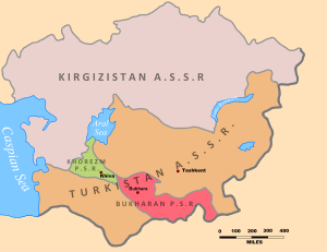
After the Communists took power in 1917 and created the Soviet Union it was decided to divide Central Asia into ethnically-based republics in a process known as National Territorial Delimitation (or NTD).
[2] Though indeed the Soviets were concerned at the possible threat of pan-Turkic nationalism,[3] as expressed for example with the Basmachi movement of the 1920s, closer analysis informed by the primary sources paints a much more nuanced picture than is commonly presented.
[9][10] Furthermore, NTD also aimed to create ‘viable’ entities, with economic, geographical, agricultural and infrastructural matters also to be taken into account and frequently trumping those of ethnicity.
[11][12] The attempt to balance these contradictory aims within an overall nationalist framework proved exceedingly difficult and often impossible, resulting in the drawing of often tortuously convoluted borders, multiple enclaves and the unavoidable creation of large minorities who ended up living in the ‘wrong’ republic.
[16][17] The process was to be overseen by a Special Committee of the Central Asian Bureau, with three sub-committees for each of what were deemed to be the main nationalities of the region (Kazakhs, Turkmen and Uzbeks), with work then exceedingly rapidly.