Kempraten
It is located on the right-hand (northeastern) shore of Lake Zurich (German: Zürichsee) northerly of Rapperswil on the so-called Kempratnerbucht, literally "Bay of Kempraten".
This natural indentation on the eastern lake shore extends between Feldbach, Hombrechtikon, and Rapperswil on a length of about 3 kilometres (2 mi).
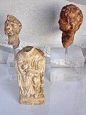
[1][2][3] Among the highlights of archaeological relicts include the Neolithic Seegubel site and La Tène culture body burials which indicates an early settlement.
[4] Beginning in the 1st century AD, the Roman vicus Centum Prata (100 meadows) has been an important Roman settlement to secure the province borders, and was both a stage town on the intersection of the streets to Zürich (Latin Turicum), Winterthur (Vitudurum) via Irgenhausen (Irgenhausen Castrum) and to Chur (Curia Rhaetorum) to Rome's alpine route.
After the Alamannic invasion and withdrawal of the Roman administration to Italy around the year 401 (488), the Gallo-Roman, probably Christianized population has been still living there.
On 1 January 2007 the former municipalities of Rapperswil and Jona merged to form a new political entity: Rapperswil-Jona that became the second largest town in the canton after the capital St. Gallen itself.