Kerguelen Islands
There are no indigenous inhabitants, but France maintains a permanent presence of 45 to 100 soldiers, scientists, engineers, and researchers.
Before being officially catalogued in 1772, the Kerguelen Islands appear as the "Ile de Nachtegal" on Philippe Buache's 1754 map entitled Carte des Terres Australes comprises entre le Tropique du Capricorne et le Pôle Antarctique où se voyent les nouvelles découvertes faites en 1739 au Sud du Cap de Bonne Esperance ('Map of the Southern Lands contained between the Tropic of Capricorn and the Antarctic Pole, where the new discoveries made in 1739 to the south of the Cape of Good Hope may be seen').
On 6 January 1774 he commanded his lieutenant, Henri Pascal de Rochegude, to leave a message notifying any passers-by of the two passages and of the French claim to the islands.
[7] Thereafter, a number of expeditions briefly visited the islands, including the third voyage of Captain James Cook in December 1776.
[11] In 1825, the British sealer John Nunn and three crew members from Favourite were shipwrecked on Kerguelen until they were rescued in 1827 by Captain Alexander Distant during his hunting campaign.
[17] For the 1874 transit, George Biddell Airy of the U.K. Royal Observatory organised and equipped five expeditions to different parts of the world.
Observatory Bay was also used by the German Antarctic Expedition, led by Erich Dagobert von Drygalski in 1902–1903.
In 1924, it was decided to administer these territories (in addition to that portion of Antarctica claimed by France and known as Adélie Land) from Madagascar; as with all Antarctic territorial claims, France's possession on the continent is held in abeyance until a new international treaty is ratified that defines each claimant's rights and obligations.
In 1908, the French explorer Raymond Rallier du Baty made a privately funded expedition to the island.
Thomas Nelson and Sons: London, 1917) describes the months that he spent surveying the island and hunting seals to finance his expedition.
In 2004 they were permanently transformed into their own entity (keeping the same name) but having inherited another group of five very remote tropical islands, les îles Éparses, which are also ruled by France and are dispersed widely throughout the southern Indian Ocean.
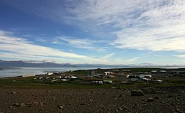
Facilities there include scientific-research buildings, a satellite tracking station, dormitories, a hospital, a library, a gymnasium, a pub, and the chapel of Notre-Dame des Vents.
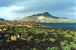
The highest point is Mont Ross in the Gallieni Massif, which rises along the southern coast of the island and has an elevation of 1,850 metres (6,070 ft).
The most important ones are listed below: There are also a number of notable localities, all on La Grande Terre (see also the main map): From 1968 to 1981, a site just east of Port-aux-Français was a launching site for sounding rockets, some for French (Dragon rockets), American (Arcas) or French-Soviet (Eridans) surveys, but at the end mainly for a Soviet program (M-100).
Since 1992, the French Centre National d'Études Spatiales (CNES) has operated a satellite and rocket tracking station, located four kilometres (2+1⁄2 mi) east of Port-aux-Français.
Other forms of volcanism are present locally, such as the strombolian volcano Mont Ross, and the volcano-plutonic complex on the Rallier du Baty Peninsula.
Glaciation caused the depression and tipping phenomena which created the gulfs at the north and east of the archipelago.
The Kerguelen Subcontinent finally sank 20 million years ago and is now one to two kilometres (550 to 1,100 fathoms) below sea level.
The west coast receives almost continuous wind at an average speed of 35 km/h (19 kn; 10 m/s) because the islands are between the Roaring Forties and the Furious Fifties.
Plant life is mainly limited to grasses, mosses, and lichens, although the islands are also known for the indigenous, edible Kerguelen cabbage, a good source of vitamin C to mariners.
In the 1950s and 1960s, French geologist Edgar Albert de la Rue began to introduce several species of salmonids.