Kettle Creek (Pennsylvania)
Kettle Creek is a tributary of the West Branch Susquehanna River running through Tioga, Potter, and Clinton counties, in Pennsylvania.
The Kettle Creek watershed has an area of 244 square miles (630 km2) in Tioga, Potter, Clinton, and Cameron Counties.
Its course takes on a west-southwest direction and it passes by the community of Oleona, where it picks up the tributary Little Kettle Creek.
The creek passes Keeney Mountain and several more hollows before turning west-northwest briefly to pick up the tributary Cross Fork in the southwestern reaches of Stewardson Township.
The creek then meanders several miles through Noyes Township, passing strip mines and another gauging station.
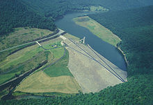
[9] At the United States Geographical Survey stream gauge downstream of the Alvin R. Bush Dam, the load of iron in Kettle Creek is 265.3 pounds (120.3 kg) per day.
[11] The concentrations of chromium, nickel, copper, zinc, arsenic, cadmium, and lead in Kettle Creek and its tributaries are so small as to be undetectable.
The acid mine drainage enters Kettle Creek, among other streams in the area and the sources of it have an average discharge of 479 gallons per minute.
[8] The highest elevation in the Kettle Creek watershed is 2,512 feet (766 m) above sea level, in the Cross Fork sub-watershed.
[14] The soils in the lower part of the Kettle Creek watershed are highly acidic, deep, and well-drained.
[10] The Kittanning Coals are found in high-elevation areas of the lower reaches of the Kettle Creek watershed.
[10] The Clearfield-McIntyre Syncline runs through the western lower part of the Kettle Creek watershed in a southwest-to-northeast direction.
[3] In the southern reaches of the watershed, where Pennsylvanian-epoch sandstones are located, the creek flows through steep valleys with narrow floodplains.
This part of the watershed is characterized by wider floodplains, less steep valleys, and some plateaus, enabling agricultural and residential development to a limited extent.
[3] The steepest basin in the Kettle Creek watershed is in the Alvin Bush Lake sub-watershed, with an average slope of 19.12 degrees.
[15][17] Much of the private and agricultural land is either in the northern reaches of the watershed, near Germania, or in or near the lower Kettle Creek valley.
There are a number of villages in the watershed, including Westport, Cross Fork, Oleona, Carter Camp and Germania.
In 1784, at the Treaty at Fort Stanwick, much of Pennsylvania's Northern Tier, including the Kettle Creek watershed, was purchased from the Iroquois, Delaware, and Wyandott for $7000.
[18] Richard Gilmore was the first person of European descent to lay claim to a plot of land on Kettle Creek.
[18] The Norwegian violinist Ole Bull attempted unsuccessfully to start a colony in the Kettle Creek watershed in 1852.
[18] Logging, including cutting down hemlock trees, was historically done in the upper Kettle Creek watershed.
The population had peaked around 1900 and numerous residents of the watershed left shortly after the collapse of the area's lumbering industry.
[8] There are two exposed petroleum pipelines on Kettle Creek between the Rauch Road Bridge and the mouth of the tributary Long Run.
[15] Bald eagles, ospreys, Canada geese, herons, and mallard ducks have visited Kettle Creek Lake.
[14] On Twomile Run above the acid mine drainage, a total of 19 macroinvertebrate taxa including 5 members of the orders Ephemeroptera and Plecoptera were observed in 1998.
Above the acid mine drainage on Middle Branch, ten macroinvertebrate taxa were observed, of which five belonged to Ephemeroptera or Plecoptera.
The Hilsenhoff Biotic Index is a method of determining water quality based on the presence of macroinvertebrate families and their tolerance to pollution.
[14] A quarter of a mile downstream of a wooden bridge built across Kettle Creek in 2000, the canopy coverage is 30%.
The upper reaches of Kettle Creek are also referred to as a "world-renowned" trout fishery by the Pennsylvania Department of Environmental Protection.
[18] The Pennsylvania Department of Conservation and Natural Resources has constructed an ATV trail in the Huling Branch sub-watershed.